


|
||

|

|
|

|
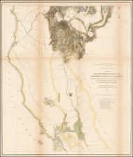
Early Appearance of Arizona Territory, South of New Mexico
Gorgeous large format map of the Western United States from Kiepert's Neuer Atlas. The map was reprinted several times and each iteration changed the layout of the territories.
Washington Territory extends into the Rocky Mountains by way of the Idaho panhandle. Idaho itself is extended further east, with Jackson Hole effectively on the border with Wyoming and the upper Wind River Mountains in Idaho. The northwest boundary of Arizona is extended. Central Nevada remains mostly unmapped and is labeled "Root Diggers," referring to a Piute tribe that practiced agriculture.
Wheat calls this "a charming map…of surprising worth," though he goes on to lament its lack of trails and railroad routes.
It is easy to see why Wheat found the map most appealing. The map includes striking and highly accurate topographical features, extensive details on forts, Indians, mountains, rivers, and all sorts of other early information. In this regard, the map is equal, if not superior, to most contemporary American Atlas maps.
![(Dallas, Texas) USAF Target Complex Mosaic-Series 25 [Sheets 0 - 4]](https://storage.googleapis.com/raremaps/img/small/87119.jpg)
![[ Texas-Mexico Border Treaty ] Que á efecto de facilitar el cumplimienio [i.e. cumplimiento] del art. 3. del Tratado de limites entre estos Estados y los Unidos del Norte América ... Habiéndose concluido y firmado en la Ciudad de México á los 12 dias del mes de Enero de 1828, un tratado entre los Estados-Unidos Mexicanos y los Estados-Unidos de América [A Treaty having been concluded and signed in the City of Mexico on the 12 day of January 1828 between the United States of America and the Mexican United States for the purpose of establishing the true dividing line and boundary between the two nations]](https://storage.googleapis.com/raremaps/img/small/100806.jpg)