


|
||

|

|
|

|
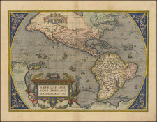
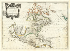
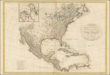
The Second Large Sanson Map of North America
First state of the Sanson-Mariette map of North America, first issued in 1669.
This atlas map was produced by Guillaume Sanson and Pierre Mariette after the death of Guillaume's father, Nicolas, in 1667. The map is drawn on the sinusoidal projection, which is also called the Sanson-Flamstead projection.
It is a reduced-size copy of Nicolas Sanson's four-sheet wall map of North America, published in 1666, which survives in only two known examples (one dated 1666, one dated 1667). However, this map has changes as compared to its wall-map predecessor. It includes C. Blanco in California and adds R. de Nort, or the Hudson River. The shape of Iceland and the British Isles are also new.
The continent is tightly framed, with only a sliver of northern South America visible. California is shown as an island. Its shape is influenced by the Foxe depiction of 1635 and is also called the second Sanson model.
The northwest of the continent is empty and obscured by the decorative cartouche. In the northeast, Greenland appears connected to North America. New North Wales seemingly floats in northern Hudson’s Bay, giving way to another coastline, New Denmark. This trails southwest-ward to a Mer Glaciale—the dream of a Northwest Passage is alive and well on this map. Much of this configuration is inspired by Thomas Button’s trip to Hudson’s Bay in 1612-3, when he named Port Nelson and Ne Ultra. Button’s Bay is named for him. Luke Foxe, on another voyage seeking the passage in 1631, named the area New Wales.
The center of the continent is dominated by Quivira. This toponym refers to the Seven Cities of Gold sought by the Spanish explorer Francisco Vasquez de Coronado in 1541. In 1539, Coronado wandered over what today is Arizona and New Mexico, eventually heading to what is now Kansas to find the supposedly rich city of Quivira. Although he never found the cities or the gold, the name stuck on maps of southwest North America, wandering from east to west.
States and rarity
There are two states of this map, which featured in Les Cartes Génerales de toutes les parties du Monde.
- Dated 1669.
- Dated 1690. Has the addition of North Pacific chimeric islands and the words, “N. Yorq aut” and “N. YORC” in the title.
This Guillaume Sanson atlas map of North America is much scarcer than that of his father (1650).
The popular misconception of California as an island can be found on European maps from the sixteenth through the eighteenth centuries. From its first portrayal on a printed map by Diego Gutiérrez, in 1562, California was shown as part of North America by mapmakers, including Gerardus Mercator and Abraham Ortelius. In the 1620s, however, it began to appear as an island in several sources. While most of these show the equivalent of the modern state of California separated from the continent, others, like a manuscript chart by Joao Teixeira Albernaz I (ca. 1632) now in the collection of the National Library of Brasil shows the entire western half of North Americas as an island.
The myth of California as an island was most likely the result of the travel account of Sebastian Vizcaino, who had been sent north up the shore of California in 1602. A Carmelite friar, Fray Antonio de la Ascensión, accompanied him. Ascension described the land as an island and around 1620 sketched maps to that effect. Normally, this information would have been reviewed and locked in the Spanish repository, the Casa de la Contratación. However, the manuscript maps were intercepted in the Atlantic by the Dutch, who took them to Amsterdam where they began to circulate. Ascensión also published descriptions of the insular geography in Juan Torquemada’s Monarquia Indiana (1613) (with the island details curtailed somewhat) and in his own Relación breve of ca. 1620.
The first known maps to show California as an island were on the title pages of Antonio de Herrera’s Descripción de las Indias Occidentales (1622) and Jacob le Maire's Spieghel Der Australische Navigatie (1622). Two early examples of larger maps are those by Abraham Goos (1624) and another by Henry Briggs, which was included in Samuel Purchas’ Hakluytus Posthumus or Purchas his Pilgrimes (1625). In addition to Briggs and Goos, prominent practitioners like Jan Jansson and Nicolas Sanson adopted the new island and the practice became commonplace. John Speed’s map (1626-7), based on Briggs’ work, is well known for being one of the first to depict an insular California.
The island of California became a fixture on mid- and late-seventeenth century maps. The island suggested possible links to the Northwest Passage, with rivers in the North American interior supposedly connecting to the sea between California and the mainland. Furthermore, Francis Drake had landed in northern California on his circumnavigation (1577-80) and an insular California suggested that Spanish power in the area could be questioned.
Not everyone was convinced, however. Father Eusebio Kino, after extensive travels in what is now California, Arizona, and northern Mexico concluded that the island was actually a peninsula and published a map refuting the claim (Paris, 1705). Another skeptic was Guillaume De L’Isle. In 1700, De L’Isle discussed “whether California is an Island or a part of the continent” with J. D. Cassini; the letter was published in 1715. After reviewing all the literature available to him in Paris, De L’Isle concluded that the evidence supporting an insular California was not trustworthy. He also cited more recent explorations by the Jesuits (including Kino) that disproved the island theory. Later, in his map of 1722 (Carte d’Amerique dressee pour l’usage du Roy), De L’Isle would abandon the island theory entirely.
Despite Kino’s and De L’Isle’s work, California as an island remained common on maps until the mid-eighteenth century. De L’Isle’s son-in-law, Philippe Buache, for example, remained an adherent of the island depiction for some time. Another believer was Herman Moll, who reported that California was unequivocally an island, for he had had sailors in his offices that claimed to have circumnavigated it. In the face of such skepticism, the King of Spain, Ferdinand VII, had to issue a decree in 1747 proclaiming California to be a peninsula connected to North America; the geographic chimera, no matter how appealing, was not to be suffered any longer, although a few final maps were printed with the lingering island.
The son of famous French cartographer Nicolas Sanson, Guillaume (1633-1703) carried on his father's work. Like his sire, he was a court geographer to Louis XIV. He often worked in partnership with another prominent cartographer of the time, Hubert Jaillot.
![[ Trans-Atlantic Cable ] Amerique Septentrionale avec l'indication des Principaux Courants marins d'Amerique en Europe](https://storage.googleapis.com/raremaps/img/small/98084.jpg)