|
||

|

|
|

|
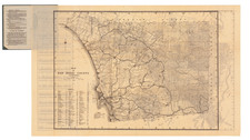
John C. Hays Survey Map of Rancho Valle de San Felipe -- Early Appearance of the San Felipe Station
Important early hand drawn survey map of Rancho Valle de San Felipe in San Diego County, by John Coffee Hays.
While the map is dated May 1868, we believe the date is erroneous and should be 1858, as Hays was active in San Diego County in 1858 and the surviving survey work bearing his name tends to be between 1854 and 1860. Moreover, all other internal evidence supports a date of 1858.
As noted below, Rancho San Felipe was an important early crossroads in early California history, the location of the earliest road to Southern California from Sonora and later the location of the San Felipe Station, which from 1858 to 1877 served as an important stop on the overland route between Yuma and Southern California.
Of particular note in this regard is the location of "Godrey's House." While we were unable to locate confirmation, this would seem to be the earliest map to reference and locate the house which would become known as San Felipe Station. In fact, we were completely unable to locate any reference to whom Godfrey might have been, but the location of the house is almost certainly the house built in 1858 which became San Felipe Station.
The present map is apparently the final survey of the lands prepared in conjunction with the confirmation of the San Felipe Rancho to John (Don Juan) Forster. Forster, an English born Californian who emigrated to Mexico at the age of 16, is perhaps best known for his ownership of Rancho Trabuco and Rancho Mission Viejo, including the Mission San Juan Capistrano.
The map notes that "the field notes of the Valle de San Felipe Rancho and from which this Plat has been made out have been "examined and approved and are on file in [the] U.S. Surveyor General Office San Francisco, California December 18th 1858 JW Mandeville . . . ." The map is countersigned as a "true copy of the Original," by George A. Pendleton, County Clerk and Recorder from 1857 to 1871.
Early place names on the map include:
- Indian Rancheria (2 places)
- Godfrey's House (San Felipe Stage Station)
- Yuma Road (2 places)
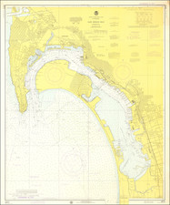
The San Felipe Valley and Rancho Valle de San Felipe
The San Felipe Valley is located to the east of Julian, California, immediately east of Banner Grade. San Felipe Valley was the ancestral home of the Kumeyaay people and in the 19th century a village site was located in the valley near Scissors Crossing. At various times, the valley as also been called Earthquake Valley or Valle de San Felipe.
The Valley became the route of the Sonora Road into the coastal region of Southern California. The Sonora Road, discovered by Mexican soldiers, reestablished land communications between Alta California and Sonora, Mexico in the late 1820s. From the time of the Mexican American War and the California Gold Rush the Sonora Road became the route of the Southern Immigrant Trail that passed through the valley from Blair Valley to Teofulio Summit, (formerly Warner Pass). This trail remained the major southern route into California from the eastern United States until the advent of the railroad at Yuma, Arizona in 1877 reduced its importance. From 1858 the important San Felipe Station of the Butterfield Overland Mail was located about a quarter mile north of Scissors Crossing, at the southeast corner of the Valley. Stage lines continued to use the route until the railroad came to Yuma.
The land route opened in 1828 between Sonora, Mexico and Alta California, the Sonora Road, extended northwest up the valley to Warner's Pass at the top of the valley, on its way to Los Angeles. The Sonora Road later became the route of Kearny and Cooke whose Mormon Battalion created Cooke's Wagon Road along the route from Yuma Crossing. Beginning in 1849, the road was heavily traveled by Forty-niners and later immigrants to California, which became the Southern Immigrant Trail. Today, the Pacific Crest Trail passes along the eastern perimeter of the Valley.
Beginning in 1857, the valley was used as a water and rest stop by the stage coaches of San Antonio-San Diego Mail Line. By 1858 the Butterfield Overland Mail had established San Felipe Station (constructed by Warren F. Hall). San Felipe Station became a major stage stop on the Butterfield Overland Mail and the headquarters for the Mail Agent in charge of the twelve stage stations between Warner's Ranch and Fort Yuma. San Felipe Station was located 10 miles southeast of Warner's Ranch and 18 miles northeast of Vallecito Station. The station served as a storage depot for up to 48 tons of barley and 36 tons of hay for the desert relay or swing stations.
Rancho Valle de San Felipe was a 9,972-acre Mexican land grant in present-day San Diego County, given in 1846 by Governor Pío Pico to Felipe Castillo. The grant was located in the San Felipe Valley. Rancho Valle de San Felipe was granted to Felipe Castillo in 1846. On his death in 1848, Castillo left the land to his four children, who in turn sold the rancho to John (Don Juan) Forster in 1850. John Forster (1815–1882), born in England, moved to Mexico at age 16 and came to California in 1833. In 1837, he married Ysidora Pico, sister of Pío and Andrés Pico. Forster accumulated a number of important ranchos over the course of his life.
With the cession of California to the United States following the Mexican-American War, the 1848 Treaty of Guadalupe Hidalgo provided that the land grants would be honored. As required by the Land Act of 1851, a claim for Rancho Valle de San Felipe was filed with the Public Land Commission in 1852, and the grant was patented to John Forster in 1866.
Forster later sold Rancho Valle de San Felipe to François Louis Alfred Pioche (1818–1872), a San Francisco financier.
From 1861 to 1865, during the American Civil War, San Felipe Station was a military outpost of the Union Army called Camp San Filipe, a rest stop on the road between California and Fort Yuma and the Arizona and New Mexico Territories. After the war, later stage lines from California to Arizona used the station from 1867 to 1877, before the railroad reached Fort Yuma making the stage route obsolete.
Rarity
The present map is seemingly a unique survival.
An image of the original disegno manuscript map exists which outlines the original Mexican land grant: ttps://calisphere.org/item/ark:/13030/hb0t1n98q9/
John Coffee "Jack" Hays was a captain in the Texas Rangers and a military officer of the Republic of Texas. Hays served in several armed conflicts from 1836 to 1848, including against the Comanche people in Texas and during the Mexican–American War. With the Gold Rush, Hays relocated to California, becoming a successful real estate investor and rancher, before serving in the Civil War.
In 1836, Jack Hays migrated to the Republic of Texas. Sam Houston appointed him as a member of a company of Texas Rangers because he knew the Hays family from his Tennessee years. Jack met with Houston and delivered a letter of recommendation from then-President Andrew Jackson his great uncle.
Hays would go on to lead the Rangers on a campaign against the Comanche in Texas. Jack rode with an Apache Chief named Flacco who led the charge into every battle with him. In 1840 Tonkawa Chief Placido and 13 scouts joined with the Rangers to track down a large Comanche war party, culminating at the Battle of Plum Creek.
Later, Hays commanded a Ranger force against the invasion from Mexico of 1842. During the Mexican–American War (1846–1848), Hays commanded the First Regiment of Texas Rangers at the Battle of Monterrey and led forces along the Texas border. He then commanded the Second Regiment of Texas Rangers in Winfield Scott's Mexico City campaign.
In 1849, Hays was appointed by the United States government as the US Indian agent for the Gila River country in New Mexico and Arizona. The same year the Hays led a party of Forty Niners from New York that traveled in wagons to California from Texas. This party pioneered a shortcut on Cooke's Wagon Road that saved a long journey to the south. That improved route became known as the Tucson Cutoff.
Hays was elected sheriff of San Francisco County in 1850, and later became active in politics. In 1853, he was appointed US surveyor-general for California.
Hays was one of the earliest residents of the city of Oakland. In the following years, he amassed a considerable fortune through real estate and ranching enterprises. In 1860, while in Virginia City, Nevada, on business, he heard the news of the First Battle of Pyramid Lake. He commanded a force of volunteer soldiers at the Second Battle of Pyramid Lake.
In 1876, Hays was elected as a delegate to the Democratic Party national convention, which nominated Samuel J. Tilden for the presidency of the United States.
![(California Gold Rush Artist) [Autograph Letter, from American artist William McIlvaine Jr. to artist William Thompson Russell Smith, mentioning Fronconia Notch. White Mountains]](https://storage.googleapis.com/raremaps/img/small/97179.jpg)
![[Lake Tahoe - Sierra Nevada - Gold Country] Scenic Highways](https://storage.googleapis.com/raremaps/img/small/63009.jpg)