


|
||

|

|
|

|
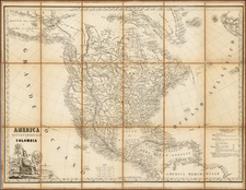
Rare decorative map of North America, published jointly by Maggi in Torino and Stucchi in Milan.
The map is largely reminiscent of the Fredonia map by R.H. Laurie and contemporary French maps by Brue and Lapie.
The map shows a a fine depiction of the travels of Lewis & Clark, Pike, Humboldt and and Stephen Long. One of the mythical rivers of the West extends to Lake Timpanogos, but the second river is truncated in a range of mountains extending from the Bay area to just south of the lower (mythical) Salt Lake.
Excellent detail east of Salt Lake. Ft. Mandan and Ft. Mannel are shown on the upper Missouri, and many of the Hudson Bay Trading Houses are shown, including Chesterfield, Nelson, Acton, Buckingham, Hudson, Carlton, Cigna, Albany, Grant, Pine, Brandon, and others, a few of which are unnamed.
Galveston and the Presidio appear in Province of Texas, among other places. Many forts and Indian Tribes named in the west and Mississippi and Missouri River Valleys.
The Missions of California are all named. Remarkable crisp engraving style, with a decorative cartouche.
The reference to Colombia is highly unusual, perhaps the only 19th Century map we know of to use this name.
Rarity
The map is apparently unrecorded. A gorgeous wide margined example A gorgeous wide margined example, which was apparently intended as sheet No. 5 in Stucchi's Grande Atlante universale.
We previously sold and 1830 editions of the map in 2004.
![Nord-Amerika [North America]](https://storage.googleapis.com/raremaps/img/small/91328.jpg)
![The Theatre of War in North America, with the Roads, and Tables, of the Superficial Contents, Distances, &c.a By and American [with] A Compendious Account of the British Colonies in North-America.](https://storage.googleapis.com/raremaps/img/small/81762.jpg)
![(North America) ПОЛИТИЧЕСКАЯ КАРТА СЕВЕРНОЙ АМЕРИКИ. [Political Map of North America]](https://storage.googleapis.com/raremaps/img/small/90261.jpg)
![Colton's North America [Wyoming attached to Dakota]](https://storage.googleapis.com/raremaps/img/small/98345.jpg)
![[ Chinese Voyages To America, etc. ] Memoires De Litterature, Tires Des Registres De L'Academie Royale Des Inscriptions et Belles-Lettres Depuis l' annee M. DCC. XVIII. julques & compris l'annee M. DCC. XXV Tome Quarante-Neuvieme](https://storage.googleapis.com/raremaps/img/small/101296.jpg)