|
||

|

|
|

|
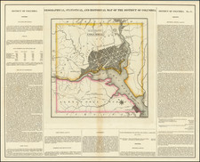
One of the earliest obtainable large format plans of the City of Washington, based upon Andrew Ellicott's seminal plan.
Reid's map of Washington is the third earliest plan of the City of Washington, preceded only by the 2 official plans, published in 1792.
The plan shows Georgetown, the street layout for Washington proper, President's House, Capitol, large green, etc. Attractive compass rose and a decorative cartouche. A scarce and desirable early large format map of Washington.
On January 24, 1791, President George Washington announced the permanent location of the national capital, a diamond-shaped ten-mile tract at the confluence of the Potomac and Eastern Branch Rivers. The original survey was performed by Andrew Ellicott and Benjamin Banneker (a freed slave). In March of 1791, Major Pierre Charles L'Enfant was appointed by Washington to prepare a plan for the new city, with Andrew Ellicott serving as L'Enfant's assistant. L'Enfant turned out to be difficult to work with, and Thomas Jefferson and Washington ultimately suspended L'Enfant's participation in the project in 1792.
Andrew Ellicott took over the project using, L'Enfant's model as his base for completing the plan of the City. Philadelphia engravers James Thackera and John Vallance and Boston's Samuel Blodget Jr. were hired to produce engraved versions of Ellicott's manuscript plan. However, prior to the release of the large official plans, both engravers also engraved and printed a smaller version of the map. An edition of the map was also printed from Hill's map in red on linen, as a keepsake.
As noted above, before the completion of the official editions of the map, smaller magazine versions of both maps, engraved by Hill and Thackara & Vallance, appeared in The Universal Asylum And Columbian Magazine (Thackara & Vallance, published March 1792) and the Massachusetts Magazine (Hill, published in about April 1792), thereby becoming the first and second printed maps of the City of Washington. The proof states of the larger official maps were not available until June and July of 1792.
This map represents the first large format map of Washington to appear after the two editions of the so-called "Official Map".
States of the Map
The present example is the first edition of the map, which appeared in Winterbotham' s An Historical Geographical, Commercial and Philosophical View of the United States, published in New York in 1795 and includes the credit line of "Published by I. Reid, L. Wayland and C. Smith, 1795," whereas the second edition credit only "I. Reid" and omits the date. Reid's map was also issued in 1795 in London, with the engraver's name listed as John Russell.
Following Mathew Carey’s publication of the American Atlas in 1795, the second large format atlas published in America was produced by John Reid of New York in 1796. The project began as an atlas to accompany William Winterbotham’s An Historical, Geographical, Commercial and Philosophical View of the United States, but was also sold separately under the title The American Atlas.
Reid’s atlas included 20 maps. In addition, John Russell’s plan of Washington, D.C. is also bound into some copies of the Atlas. Reid’s atlas was a collaborative work, with 9 of the maps engraved by Benjamin Tanner, 5 by David Martin, two by D. Anderson and one each by John Scoles and John Roberts. Two of the maps do not include engraving credits. Each of the engravers was probably working in New York (including Tanner, who had not yet relocated to Philadelphia). According to the various entries for the maps in Wheat & Brun, the cartographic content of the maps is drawn largely from Carey’s first atlas of 1795.