This item has been sold, but you can enter your email address to be notified if another example becomes available.


|
||

|

|
|

|
Stock# 75891
Description
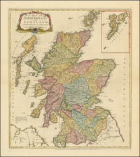
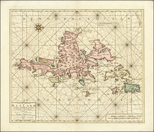
Attractive Tardieu map of Scotland, showing the various counties, cities, and topography. Relief is shown pictorially. The detail in northern and western Scotland is extensive and accurate. The inner and outer Hebrides are all named and shown, as well as the Orkneys. The mainland is also referred to as Pomona, the result of a mid-16th century mistranslation of Solinus.
An attractive decoration on the upper left side of the map shows an unusual geological formation in Scotland, comparable to Giant's Causeway in Ireland. This is likely a basaltic sill that has cooled and cracked to form a hexagonal pattern.
![Ireland [and] Scotland](https://storage.googleapis.com/raremaps/img/small/92586.jpg)