|
||

|

|
|

|
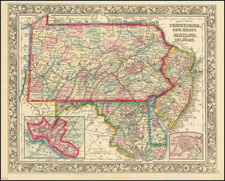
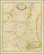
Fine Early Map of the State of New Jersey
Nice example of Mathew Carey's map of New Jersey, first published in Carey's General Atlas in 1814. Carey's map is one of the earliest obtainable separately published maps of New Jersey following the American Revolution. It pre-dates Gordon's map of New Jersey (the first large format map of New Jersey printed after the American Revolution) which was not published until 1828. The Gordon map is generally considered the most important map of New Jersey published in the 19th century.
The map is exceptionally precise for the period, being one of the earliest maps to show in detail the road system of New Jersey, along with early towns, rivers, mountains, and other details.
Mathew Carey is most known for publishing the first atlas of American maps in 1795, compiling a number of excellent maps from indigenous sources. This 1814 edition of Carey's General Atlas updated his previous works with additional detail and maps.
An essential map for New Jersey collectors.