


|
||

|

|
|

|
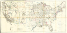
The First Coast to Coast Map of the United States Published By the General Land Office
First edition of this detailed large format map of the United States, illustrating the extent of the public surveys conducted by the General Land Office through 1866.
Issued shortly after the creation of Montana Territory (May 1864) and just prior to the creation of Wyoming Territory (July 1868), the map shows the state of the evolving Western Territorial Boundaries in the year after the Civil War. The configuration of Idaho Territory and the western part of Dakota Territory is particularly interesting. The Idaho-Montana Boundary would undergo significant modifications over the coming years, with the small section of Dakota Territory north of the Tetons later becoming part of Montana and the whole of the region reconfigured to accommodate the future Yellowstone National Park, which is virtually unexplored in the present map.
While the map does a credible job of locating township surveys, early roads and other important features, the primary feature of the map west of the Rocky Mountains is the extensive mineralogical detail in the map, noting the presence of Gold, Silver, Copper, Quicksilver, Iron, Tin, Asphaltum, Coal and Oil, in the mineral rich regions west of the Rocky Mountains.
Following the publication of a similar map in 1864 and 1865, which cut of the Northeastern United States, beginning in 1866, the General Land Office began issuing this remarkable large format map of the United States, full of the most up to date information from surveys being conducted throughout the Western States, including the extent of the public surveys, locations of US Surveyor and Land Offices, the location of Land Grants in the West, Railroads and Proposed Railroads, Land Districts, and the mineral deposits known at the end of the Civil War. With the Civil War at its conclusion and the Transcontinental Railroad construction in high gear, it was time for America to compile a visual depiction which tracked the progress of the survey, settlement and commercial development of the lands west of the Mississippi, in a single map.
Between 1866 and 1870, under the auspices of the General Land Office, a series of maps was produced to accompany the annual reports of the Commissioner of the General Land Office. Initially, the maps were also widely distributed outside the United States, with copies issued as separate maps, bound in covers which translated the title into French, German and other languages, providing notice to the world that the United States was exercising dominion over all its lands from coast to coast and was a ripe place for investment and immigration.