![Nouvelle Carte Du Mexique, Du Texas Et D'Une Partie Des Etats Limitrophes . . . 1840 [Proposed Railroads In Texas -- First Appearance of Arizona on a Printed Map] By Adrien-Hubert Brué](https://storage.googleapis.com/raremaps/img/small/103480.jpg)


|
||

|

|
|

|
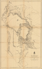
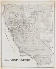
The First Appearance of Jedidiah Smith's Route on a Printed Map
First Map to Name Arizona
Brue's wall map of Mexico is one of the most important maps of the region during the period.
Wheat described the map as a monumental map, much on the order of the Arrowsmith and Wyld maps of the period.
Brue's map provides the first cartographic representation of Jedediah Smith's journey to California and return in 1826. Carl Wheat, in Mapping the Transmississippi West, notes:
In fact, a most important map of 1834 - historically speaking - was that of A.H. Brue, also published posthumously by his widow. It was a map of Mexico, beautifully engraved, as were all the maps of this cartographer. It… carries many of the legends of the 1833 Brue map [of North Amreica]. On this map, however, a line has been added from the Lac Teguayo (Lac Sale) area south to the R. Adams, thence southwest past the Rock Salt Cavern to the Seeds-Keeder River, and finally across to San Diego, the line being labeled in the north 'Route de Smith en 1826' and farther south merely 'Route de Smith'… All but one of the names mentioned by Jedediah Smith in his letter dated October 11, 1827… are present on this map…
The information was derived from a letter from Smith published for the first time in the Nouvelles Annales des Voyages in Paris, in 1828.
The map is also of note for its treatment of Texas, naming Austin and showing nearly a dozen roads and many other pre-republic details.
Another fascinating addition is the appearance of "Arizona", south of the headwates of the Rio Gila, between Las Cruces and Ojo Caliente. First appearing on the 1834 edition of Brue's map, this would seem to be the earliest appearance of the name Arizona on a printed map.
The mythical river connecting Lac Timpanagos and the Pacific, via the Multnomah River is shown, as are the remnants of the mythical Rio Sacramento, extending from Salt Lake to the Pacific. The treatment of the entirety of the southern Transmississippi West is of great note and marks a milestone at the beginning of the exploration of Texas, the Rockies, California and the Southwest.
States of the Map
The map was issued in 1834, 1835 (Warren Heckrotte copy), 1837 and 1839.
In 1840, the map was re-issued with updates that included the removal of Smith's route.
Rarity
All of the 1834-1839 states of the map are extremely rare on the market. We offered a copy of the 1834 for sale in 2003. The 2015 Warren Heckrotte sale at PBA Galleries in 2015 included a copy of the 1835 state. A copy of the 1837 state appeared in a Kitt Kapp catalog in 1993.
Andre Hubert Brué was a French geographer and cartographer. Born in Paris, he served in the French Navy, joining the Baudin expedition to the Pacific (1800-1804). After his sea service, Brué applied his navigation and charting skills to creating finely-crafted maps, which were renowned for their crisp engraving and accuracy. He drew directly on the copper of the plate, creating what he called encyprotypes. He is best known for the Atlas universal de géographie physique, politique, ancienne et moderne.