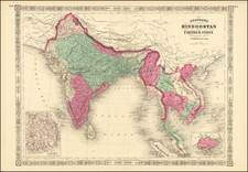
|
||

|

|
|

|
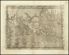
Decorative map based upon De L'Isle's landmark map of Mexico and Florida, first issued in 1703.
De L'Isle's map was the first to introduce the information from La Salle, Bienville, d'Iberville and other French explorers in America. It was the first map to accurately portray the mouth of the Mississippi and the Great Lakes region. Also accurately shown for the first time are the English settlements on the east coast.
The reports of Iberville are present in the villages in the lower Mississippi Valley and Texas, where the Spanish were active building missions and presidios. Several Dutch and German cartographers copied De L'Isle's work but added the rich embellishments present in this example.
The tracks of the Spanish galleons and routes to Havana are shown.
Johann Baptist Homann (1663-1724) was a mapmaker who founded the famous Homann Heirs publishing company. He lived his entire life in Bavaria, particularly in Nuremberg. Initially, Johann trained to become a priest before converting to Protestantism and working as a notary.
In 1702, Johann founded a publishing house that specialized in engravings. The firm flourished, becoming the leading map publisher in Germany and an important entity in the European map market. In 1715, Johann was named Imperial Geographer to the Holy Roman Empire by Charles VI and made a member of the Prussian Academy of Sciences. Most importantly for his business, his reputation and contacts gained him imperial printing privileges which protected his publications and recommended him to customers. Johann is best known for this Grosser Atlas ueber die ganze Welt, or the Grand Atlas of the World, published in 1716.
After Johann died in 1724, the business passed to his son, Christoph (1703-1730). Upon Christoph’s early death, the company passed to subsequent heirs, with the name of the company changing to Homann Erben, or Homann Heirs. The firm continued in business until 1848.
August Heinrich Petermann (1822-1878) is a renowned German cartographer of the nineteenth century. Petermann studied cartography at the Geographical Art-School in Potsdam before traveling to Edinburgh to work with Dr. A. Keith Johnston on an English edition of Berghaus’ Physical Atlas. Two years later he moved to London, where he made maps and advised exploratory expeditions as they set off to explore the interior of Africa and the Arctic.
In 1854, Petermann returned to Germany to be Director of the Geographical Institute of Justus Perthes in Gotha. There, he was the editor of the Geographische Mittheilungen and Stieler’s Handatlas. The Royal Geographical Society of London awarded him their Gold Medal in 1860. He continued his interest in exploration in Germany, fundraising for the German Exploring Expeditions of 1868 and 1869-70, which sought an open Arctic sea. Tragically, he committed suicide in 1878.

![The Theatre of War in North America, with the Roads, and Tables, of the Superficial Contents, Distances, &c.a By and American [with] A Compendious Account of the British Colonies in North-America.](https://storage.googleapis.com/raremaps/img/small/81762.jpg)