|
||

|

|
|

|
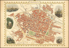
Stunning full-color example of Tallis's marvelous map of Belgium. The map extends into the rest of the Low Countries, but detail is centered on Belgium and curiously extended into Luxembourg, even though this latter was a fully independent state at the time. The various provinces of Belgium are shown in tasteful bright colors and named. Topography is shown.
The map shows vignettes of three scenes. These include delicate pastel colorings of the Altar of St. Gudule (in Brussels), Monuments on the Plains of Waterloo, and Antwerp Cathedral. In addition, a coat of arms is displayed.
This map was engraved for R. Montgomery Martin's Illustrated Atlas of the World. Tallis was one of the last great decorative map makers and his maps are prized for the wonderful vignettes they often contain.
John Tallis (1817-1876) was a British map publisher. Born in the Midlands, Tallis came to London in the 1840s. Tallis began his London career with a series of remarkable London street views. He began a partnership with a Frederick Tallis, possibly his brother, but their collaboration ended in 1849. For the Great Exhibition of 1851, Tallis published the Illustrated World Atlas, one of the last series of decorative world maps ever produced. The maps were engraved by John Rapkin, a skilled artisan. The maps were later reissued by the London Printing & Publishing Company, who left the Tallis imprint intact, thus ensuring his enduring fame. In 1858, he began publication of the popular Illustrated News of the World and National Portrait Gallery of Eminent Personages, selling it in 1861 (it ceased publication in 1863).
![[ Siege of Ostend ] Oostende](https://storage.googleapis.com/raremaps/img/small/96446.jpg)
![[Course of the Rhine River] Corso del Reno Parte Septentrio [and] Corso del Reno Parte Meridionale . . . 1690](https://storage.googleapis.com/raremaps/img/small/73095.jpg)