


|
||

|

|
|

|
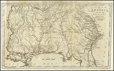
Fine early map of the Georgia, East Florida and West Florida, published by Jedidiah Morse in Boston. This early map shows Georgia extending from the Savannah River and Atlantic Ocean to the Pacific Coast, along with East and West Florida. The majority of Georgia is dominated by various Indian Tribes, including the Chicasaws, Chactaws, Muskogees and Creeks. Eastern Georgia includes about 15 counties.
A number of early roads are shown, including three which extend west to the Mississippi River. West of the Chattahoochee River, only a handful of villages are listed, primarily Indian settlements. Ft. Fidus and Ft. Matthews are shown. Mobile and Pensacola are named in West Florida.
This is one of the few American regional maps to show Georgia extending to the Mississippi.
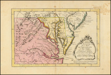
The Two Floridas
At the conclusion of the French and Indian War, Great Britain would gain possession of the Florida territories, which it would divide into East Florida (the peninsula) and West Florida (the Panhandle along with parts of Alabama and Mississippi). Poorly defined borders in the region would lead to the West Florida Controversy and several disputes between the US and Spain. The US would eventually purchase the two Floridas in several discrete installments, concluding with the Adams-Onis Treaty in 1822 which ended the history of the two states.