


|
||

|

|
|

|
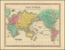
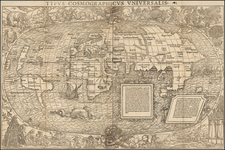
Fine example of Finley's attractive World Map on Mercator's Projection, which appeared in his A New General Atlas . . . The world is shown in great detail, with numerous rivers, cities, deserts, islands, mountain ranges and more all shown.
This map does not identify Antarctica, although it had first been reliably sighted six years prior to the creation of this map. The northern coast of the South Shetland Islands is shown. While the north coast of Russia and Finland are accurately depicted, northern North America and Greenland are left undefined. Alaska and British Columbia are denoted as Russian Possessions. Baffins Bay is closed to the north.
Anthony Finley (1784-1836) was an American map publisher. Little is known about his life. He is presumed to have been born in Philadelphia, where he also died. A publisher, Finley was also involved in several Philadelphia civic and professional societies such as the Philadelphia Apprentices’ Library. He may have been in business as early as 1809 and his first publication dates from ca. 1811.
His first maps also date from this year, with two maps in Daniel Edward Clarke’s Travels in Various Countries of Europe, Asia, and Africa. The first atlas published by Finley appeared in 1818, the Atlas classica, or, Select maps of ancient geography, both sacred and profane, for the use of colleges and schools in the United States. He is best known for his A New General Atlas Comprising a Complete Set of Maps (1824), which was a bestseller. There were two editions in 1824, with annual editions until 1834.
Finley was part of the first generation of American publishers who produced high quality, precise maps on American soil. He was in competition with other Philadelphia publishers, for example Henry S. Tanner. Finley’s A New American Atlas Designed Principally to Illustrate the Geography of the United States of America (1826) closely mirrors Tanner’s A New American Atlas Containing Maps of the Several States of the North American Union, with similar groupings of maps; the main difference is the smaller scale of Finley’s maps. Finley printed two editions of this atlas.
![(Second World War) Newsmap -- Monday, November 23, 1942 [on verso:] Life Save #2 Winning Friends - Helping People](https://storage.googleapis.com/raremaps/img/small/94937.jpg)