|
||

|

|
|

|
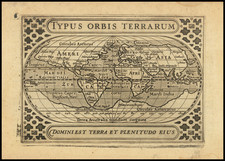
Visscher’s Bible World Map, with an Unprecedented Portrayal of Australia
Fine, dark impression of this decorative double-hemisphere world map by Nicolaus Visscher, published in Amsterdam in 1657. The map served as an important prototype for bible world maps in the late-seventeenth and early-eighteenth centuries.
Visscher takes an interestingly conservative approach as compared to other contemporary world maps. This leads to the depiction of California as a peninsula when most other mapmakers had shifted to the more recent, yet ultimately erroneous, California as an island trend.
It also means that Abel Tasman’s encounter with Van Diemen’s Land (Tasmania) is included, but his reports of New Zealand and the north coast of Australia are not. This was a striking and original way to portray Australia cartographically.
South America is split between the two hemispheres. There is no Antarctic continent; rather, a double-hemisphere celestial map is to the south in the eastern hemisphere, while a text block is in the western hemisphere. This text discusses Columbus and Vespucci’s voyages, as well as the circumnavigations of Magellan, Drake, Cavendish, van Noort, and le Maire.
The latter, le Maire, is also commemorated with the dotted line that passes around Cape Horn and sails across the Pacific. This is the route pioneered by Willem Schouten and Jacob le Maire. In 1615 to 1617, they led a circumnavigation in search of trade opportunities. It also sought to break the Dutch East India Company (VOC) monopoly on the Straits of Magellan. They did so by finding and sailing through the Straits of Le Maire and then into the open Pacific.
North America stretches far to the northwest, where it is barely separated from Asia by the Strait of Anian. This strait was related to the centuries-long quest to find a Northwest Passage connecting the Atlantic Ocean to the Pacific. The rumor of this strait and a Northwest Passage in general inspired many voyages of discovery, including those of John Cabot, Sir Francis Drake, Gaspar Corte-Real, Jacques Cartier, and Sir Humphrey Gilbert.
The term Anian itself comes from Marco Polo’s thirteenth-century accounts of his travels. Polo used the term to refer to the Gulf of Tonkin, but cartographers thought it could refer to this supposed strait between Asia and North America. The Strait of Anian, so named, first appeared in a 1562 map by Giacomo Gastaldi and was later adopted by Bolognini Zaltieri and Gerard Mercator.
Tucked between the geographic hemispheres are circular diagrams representing the Ptolemaic and Copernican solar system theories. In each corner is a vignette of a continent shown as a woman riding an animal: Africa is atop a crocodile, America an armadillo, and Asia a camel. Only Europe is without a beast to ride; instead, the bull associated with the continent wanders nearby.
Early Dutch encounters with Australia, Tasman’s voyages, and this map’s depiction of Australia
This map shares a distinctive view of Australia that only includes the west and southern coasts, along with Van Diemen’s Land. The latter was first encountered on Tasman’s first Pacific voyage (1642-3), but the other shores were charted thanks to earlier Dutch voyages that were part of the larger Dutch empire in the East Indies. Indeed, the entire continent is named t’Landt van de Eendracht, which recalls the first European ship to land in western Australia.
Whereas the Portuguese were the first Europeans to tap the lucrative resources of the East Indies, other European powers quickly joined the race. The VOC, founded in 1602, was based in Amsterdam with a local headquarters in Batavia (Jakarta). Dutch ships roved the waters of the Indian Ocean. A few crossed the sea at southern latitudes, taking advantage of the winds of the roaring forties, which put them on a collision course with the continent of Australia, then still unknown to Europeans.
These ships were following the Brouwer Route to Jakarta, so-called because it was explored in 1611 by Hendrick Brouwer. Less than five years later, it was named the prescribed route from the Cape of Good Hope to Java and following the route was compulsory for all VOC ships, unless they were destined directly for China and Ceylon, rather than Batavia. Ships were supposed to turn north when they sighted Amsterdam Island or St. Paul Island. However, the methods for calculating longitude in the seventeenth century were imprecise and some ships continued east, eventually running afoul of the Australian coast.
The first of these to contact West Australia was the Eendracht in 1616, which was blown off course en route to the East Indies. It was commanded by Dirk Hartog and Hartog’s landing was the first recorded European landing on the western coast of Australia. It is marked here with Dirk Hertochs Re and the name of the entire continent. The crew commemorated their discovery by erecting a post with a pewter dish inscribed with their ship’s information—the earliest physical record that historians have of any European landing in Australia.
Also included is Edels Landt. Jacob d’Edel, in the Amsterdam, along with Frederik de Houtman in the Dordrecht came within sight of the western coast in 1619. The Houtmans Ab. are an archipelago named for the navigator who sighted them, or at least it was Houtman who reported the islands to the VOC. The islands became infamous after the Batavia shipwrecked there in 1627. The mutiny and massacre that became Batavia’s fate fascinated all of Europe, but also flagged the islands as treacherous for ships, which is why they deserve such attention on charts. Also included is the shoal sighted by and named for the Tortelduyf in 1624.
Other voyages also sighted or landed in Western Australia in the 1620s. This map references that of Gerrit Fredericsz De Wit in 1628, of the Leeuwin in 1622, and of Pieter Nuyts, who commanded the Gulden Zeepaert along the southern coast in 1627.
By the 1640s, the officials of the VOC were eager to know the extent of the south lands and if they included any useful resources or willing trading partners. They appointed Abel Tasman to pursue these questions. Tasman's 1642-43 voyage was the first to circumnavigate the whole of the Australasia region, thus proving it was a separate entity unconnected from a mythical, and massive, southern continent. He surveyed the south coast of Tasmania, which he called Van Diemens Land after the VOC governor of Batavia, and the western coast of New Zealand, as well as the Tonga and Fiji Archipelagos. While important for geography, his voyage was nevertheless a disappointment to the VOC, as it netted no new commercial opportunities. This map curiously only integrates the coast of Tasmania.
Tasman’s second voyage proved even less successful. He was supposed to find a passage south of New Guinea to the east coast of Australia, but he missed the strait and instead thought it a bay. He did, however, more fully chart Australia’s northern coastline, which had only been sporadically encountered to that point. Previously, information for the north coast, especially for portions of the coasts in what it today Queensland, Australia, come from the voyage of the Dutch vessel Duyfken in 1605-06. Under the command of Willem Janszoon, the Duyfken explored the eastern shore of the Gulf of Carpentaria, just below the Cape York Peninsula, a venture which was famously the first recorded European contact with Australia. Interestingly, however, Visscher integrates neither the geography of the Duyfken or Tasman’s second voyage, making this map distinct among those of his fellow mapmakers of this period.
States of the map
This 1657 world map was the first of several maps which Visscher produced for Dutch bibles in the middle of the seventeenth century; it then became the prototype for many European bible maps published over the next one hundred years.
This is the first edition of the map, which appeared in the Dutch bible published by van Ravesteyn in 1657. It also appeared in later edition of the Ravesteyn Bible in 1660, 1662, 1667 and 1670. A second edition of the map—re-engraved and slightly larger, and with the addition of New Zealand—was published ca. 1660.
![[Early Fascimile of the Disputed Christopher Columbus Portolan Chart]](https://storage.googleapis.com/raremaps/img/small/66588.jpg)