|
||

|

|
|

|
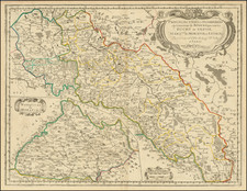
Stock# 75743
Description
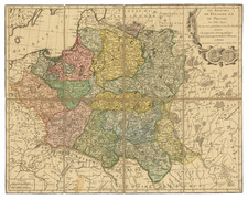
Rare, likely Spanish or Portuguese, map of Germany from the late-17th or early-18th century from an extensive atlas. The translation of Germany, the use of French miles, and general spelling suggests the Spanish origin, uncommon in atlases of the time.
The many duchies, regions, and principalities of central Europe are shown, including Bavaria, Westfalia, Prussia, Poland, Savoie, and Austria. Cities shown include Amsterdam, Berlin, Salzburg, Bamberg, and Dijon. In all, this is an attractive antique map of Germany with an unusual publication location.
![Drink Norden Kaffe [Germany]](https://storage.googleapis.com/raremaps/img/small/91604.jpg)