


|
||

|

|
|

|
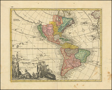
Scarce map of America, featuring a number of the most famous myths and inaccuracies that appeared on contemporary maps of the period.
California is shown as an island following the second Sanson model, including over 30 place names. The Mississippi River is shown flowing into the Gulf of Mexico near modern-day Galveston Bay, based upon La Salle's erroneous reports, which De L'Isle was just correcting in his mapping of North America around 1700.
The map also includes the mythical Terra Esonis, a massive land bridge running virtually the entire distance between North America and Asia. This landmass probably had some connection to early knowledge of the Aleutian Archipelago and pre-dates Vitus Bering's and Aleksei Chirikov's exploration of the region in 1741. The Fretum Aniani (Straits of Anian) are curiously configured, with no definite Northwest Passage but the interior of now-western Canada is left to the viewers' imagination.
The map includes some early western Indian tribal names. Most interesting are the Apaches de Novajo, north even of the Apaches de Xila, both of which are considerably north of the areas inhabited by the Apache and Navajo Indians. The projection of Florida is stumped and the Straits of Florida are exaggerated.
The elaborate cartouche depicts a number of Indians and a westerner in military costume smoking a peace pipe.
Johann Christoph Weigel (1654-1725), sometimes known as Christop Weigel the Elder, was a notable German engraver, art dealer, and publisher, renowned for his contributions to the fields of cartography and illustration during the late 17th and early 18th centuries. Born in 1654 in the city of Redwitz, in the Margraviate of Bayreuth, Weigel embarked on a career that would place him among the prominent figures in the world of European printmaking.
Weigel's early life and training are somewhat obscure, but it is known that he was active in Nuremberg, a city renowned for its vibrant artistic and cultural scene. Nuremberg was a hub for artists, craftsmen, and publishers, and it was here that Weigel honed his skills and established his reputation. He married the daughter of the prominent engraver and publisher Johann Christoph Lochner, which further integrated him into the thriving artistic community of Nuremberg.
His work encompassed various subjects, including maps, historical scenes, portraits, and scientific illustrations. Weigel's maps are particularly notable for their detail and accuracy, reflecting the growing interest in geography and exploration during his time. His cartographic works often combined practical utility with artistic embellishment, making them valuable for both navigational purposes and as works of art.
One of Weigel's significant contributions was his involvement in the production of the Atlas scholasticus et itinerarius, a comprehensive world atlas that was widely used in educational settings. This work demonstrated his skill in synthesizing geographical information into accessible and informative maps.
In addition to his cartographic endeavors, Weigel produced a vast array of illustrations for books on various subjects, ranging from history to natural science. His illustrations were known for their clarity and detail, contributing to the dissemination of knowledge in an era when visual representations were crucial for understanding complex ideas.
Weigel's legacy is that of a versatile and skilled engraver and publisher who contributed significantly to the visual culture of his time. His works provided practical information and reflected the late Baroque period's intellectual and artistic currents. Christoph Weigel passed away in 1725, leaving behind a body of work that continues to be appreciated for its artistic merit and historical value.

![Oceani Occidentalis Seu Terrae Novae Tabula [The Admiral's Map]](https://storage.googleapis.com/raremaps/img/small/102935.jpg)
![[New General Map of North and South America Showing the Routes of Kruzenshtern and Lisyansky] НОВАЯ ГЕНЕРАЛЬНАЯ КАРТА СѢВЕРНОЙ И ЮЖНОЙ АМЕРИКИ СЪ ПОКАЗАНІЕМЪ ПУТЕЙ КРУЗЕНШТЕРНА И ЛИСЯНСКАГО](https://storage.googleapis.com/raremaps/img/small/58490.jpg)