


|
||

|

|
|

|
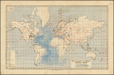
An Example of Philippe Buache's Theories on Submarine Mountain Chains, an Important Part of the Early History of Thematic Mapping
This creative map purports to show the interconnectedness of the mountain chains of the world. Mountains criss-cross the continents, but also pass through the oceans, as represented through island chains.
Many features of interest can be found; for example, the dryness of the Sahara can be explained by the fact that it is surrounded by mountains. However, to justify his theories, Buache introduces som suspicious cartographic features, such as random maelstroms and "little known" lakes.
Buache's theories, would, of course, prove to be flawed. While underwater mountain chains do exist, these "mid-ocean ridges" always strike perpendicular to the chains Buache shows. However, the similarities in the geological histories between continents, and the "connectivity" of some mountain ranges (e.g., the Norwegian Caledonides and the Appalachians) has been confirmed through detailed mapping.
The map was published in Buache's Cartes et Tables de La Geographie Physique ou Naturelle (1757).
Philippe Bauche, theoretical geography, and thematic mapping
Buache was a pioneering theoretical geographer interested in demonstrating the interconnectedness of the world’s landmasses. Starting in 1737, Buache drew a bathymetric map of the English Channel which showed "hidden features" of the channel that argued that mountain chains of England (the Pennines and South Downs) could be connected to the Alps through the straits of Dover. Two decades later, he would expand his map to cover the whole world.
Buache was also interested in watersheds, which he argued were created by interlinked mountain ranges which circled the globe. These mountain ranges provided routes for rivers to flow to the sea. Buache understood islands to be proof of mountain ranges which connected the continents. Buache presented this mountain chain idea at the Academie first in September 1737 and again in November 1752, once he had completed his worldview (seen here).
This is thought to be one of the first thematic maps, which appeared in the same decade as other famous thematic maps, such as De Lisle's first geological maps. A similar world map would also accompany Buache’s published essay on the subject, An Essay of Physical Geography, wherein it is proposed to present General Views on what may be called the Framework of the Globe, composed of mountain systems that cross seas as well as continents; with some particular remarks on the different basins of the sea, and on its interior configuration (1752).
Philippe Buache (1700-1773) was one of the most famous French geographers of the eighteenth century. Buache was married to the daughter of the eminent Guillaume Delisle and worked with his father-in-law, carrying on the business after Guillaume died. Buache gained the title geographe du roi in 1729 and was elected to the Academie des Sciences in the same year. Buache was a pioneering theoretical geographer, especially as regards contour lines and watersheds. He is best known for his works such as Considérations géographiques et physiques sur les découvertes nouvelles dans la grande mer (Paris, 1754).

![[ World Map Facsimile ] Typus Universalis Terrae, Iuxta Modernorum Distinctionem et Extensionem Per Regna et Provincias](https://storage.googleapis.com/raremaps/img/small/95596.jpg)