|
||

|

|
|

|
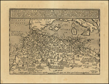
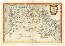
From the Nile to the Libyan Sea
Highly decorative map of the region from the Libyan Sea to the Red Sea, including Babylon, Thebes, the Pillars of Hercules, Hamorum, Alexandria, Memphis, and many other classical places.
The Nile has its origin in Aetheopia Sub Aegypto. Interesting scene of a man being swallowed by a sea monster. The map is based upon classical Ptolemaic information.
The map is largely unchanged from the 1540 edition. Munster's Geographia was a cartographic landmark, including not only Ptolemaic maps, but also a number of landmark modern maps, including the first separate maps of the 4 continents, the first map of England and the earliest obtainable map of Scandinavia. Munster dominated cartographic publication during the mid-16th Century.
Munster is generally regarded as one of the three most important map makers of the 16th Century, along with Ortelius and Mercator. Munster was a linguist and mathematician, who initially taught Hebrew in Heidelberg. He issued his first mapping of Germany in 1529, after which he issued a call geographical information about Germany to scholars throughout the country. The response was better than hoped for, and included substantial foreign material, which supplied him with up to date, if not necessarily accurate maps for the issuance of his Geographia in 1540.
Sebastian Münster (1488-1552) was a cosmographer and professor of Hebrew who taught at Tübingen, Heidelberg, and Basel. He settled in the latter in 1529 and died there, of plague, in 1552. Münster made himself the center of a large network of scholars from whom he obtained geographic descriptions, maps, and directions.
As a young man, Münster joined the Franciscan order, in which he became a priest. He then studied geography at Tübingen, graduating in 1518. He moved to Basel, where he published a Hebrew grammar, one of the first books in Hebrew published in Germany. In 1521 Münster moved again, to Heidelberg, where he continued to publish Hebrew texts and the first German-produced books in Aramaic. After converting to Protestantism in 1529, he took over the chair of Hebrew at Basel, where he published his main Hebrew work, a two-volume Old Testament with a Latin translation.
Münster published his first known map, a map of Germany, in 1525. Three years later, he released a treatise on sundials. In 1540, he published Geographia universalis vetus et nova, an updated edition of Ptolemy’s Geographia. In addition to the Ptolemaic maps, Münster added 21 modern maps. One of Münster’s innovations was to include one map for each continent, a concept that would influence Ortelius and other early atlas makers. The Geographia was reprinted in 1542, 1545, and 1552.
He is best known for his Cosmographia universalis, first published in 1544 and released in at least 35 editions by 1628. It was the first German-language description of the world and contained 471 woodcuts and 26 maps over six volumes. Many of the maps were taken from the Geographia and modified over time. The Cosmographia was widely used in the sixteenth and seventeenth centuries. The text, woodcuts, and maps all influenced geographical thought for generations.
![(Early French Colonization of North Africa--Barbary Pirates) Gigeri en Afrique, Sur la Coste de Barbarie; et la Prise par les Armees du Roy, Commandes par Mr. le Duc de Beaufort [Gigeri in Africa, On the Coast of Barbary; and its Capture by the Armies of the King, Commanded by Mr. the Duke of Beaufort]](https://storage.googleapis.com/raremaps/img/small/93494.jpg)