|
||

|

|
|

|
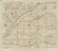
Sailing Toward The New World
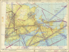
Fine sea chart of the Western Atlantic and contiguous parts of the Northeastern US and Northern South America, published by Pieter Goos in Amsterdam.
This attractive sea chart assumes the perspective of the westward direction facing upwards and embraces the Western Atlantic Ocean from the Canaries and Azores, in the east, to the eastern reaches of the American continents. It features North America from Delaware up to and including Newfoundland, the West Indies from Hispaniola through to the Barbados, and South America from eastern Colombia through to Pernambuco, Brazil.
Cartographically, the depiction of the Mid-Atlantic region, New England and eastern Canada is novel and distinct. The depiction of the American coasts running from the Delaware River to Cape Cod departs from the portrayal commonly used on contemporary Dutch charts that were largely derived from Adiaen Block's maps of 1614. On the present chart, Long Island is more correctly shown to have an elongated (as opposed to bulbous) form, while Narragansett Bay is shown to correctly open to the south (whereas the Block maps show the mouth of the bay to be sheltered by an island).
Further south, the depiction of the eastern Caribbean is relatively conventional for the time, and shows the WIC's direct experience in the region, having recently settled a number of islands, including Curaçao and Saint Martin. The coasts of South America prominently feature the mouths of the Amazon and Orinoco rivers. The mapping of Northeastern Brazil is derived from Dutch West India Company maps disseminated by Caspar Barlaeus during the recent Dutch hegemony over the region (the Portuguese only managed to evict the Dutch from the region in 1654).
Pieter Goos (ca. 1616-1675) was a Dutch map and chart maker, whose father, Abraham Goos (approx. 1590-1643), had already published numerous globes, land and sea maps together with Jodocus Hondius and Johannes Janssonius in Antwerp. Pieter gained recognition due to the publication of sea charts. He bought the copperplates of the famous guide book for sailors, De Lichtende Columne ofte Zeespiegel (Amsterdam 1644, 1649, 1650), from Anthonie Jacobsz. Goos published his own editions of this work in various languages, while adding his own maps. In 1666, he published his De Zee-Atlas ofte Water-Wereld, which is considered one of the best sea atlases of its time. Goos' sea charts came to dominate the Dutch market until the 1670s, when the Van Keulen family came to prominence.
![[ Pictish Man Holding Severed Head ] Picti icon](https://storage.googleapis.com/raremaps/img/small/99837.jpg)