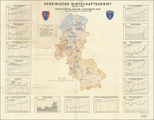
![[Battle of Berlin] План г. Берлин 1:25000 By Leningrad Military Mapping Unit](https://storage.googleapis.com/raremaps/img/small/68524.jpg)


|
||

|

|
|

|
Soviet Map of the Battle of Berlin with Contemporary Annotations Showing the 89th Armenian Rifles' Assault on the City and Participation in the Capture of the Reichstag.
Color-printed folding map of Berlin, issued by the Front Headquarters Topographic Department (Топографический Отдел Штаба Фронта) in March or April of 1945.
This example is particularly important as it records the progress across Berlin of elements of the Soviet 3rd Shock Army, namely the 89th Armenian Rifles (89-я стрелковая дивизия), during the Battle of Berlin. The annotations begin at Wilhelmsruh and continue to Invalidenstraße, followed by an emphatic circling of the Reichstag. There are three large circles with notes in Siemensstadt to the west of the city.
The 89th Armenian Rifles arrived at the Reichstag just after its capture by other elements of the 3rd Shock Army. There they famously danced the kochari (Armenian national folk dance) on what remained of the walls of the building that was seen by the Soviets to be the heart of Nazi Germany.
The use of this map in the Battle of Berlin renders this a particularly important artifact of World War II history.
Overprint Version
The map was issued in several editions in 1945. It declares itself to be derived from the original 1:15,000 mapping of Berlin. The editions can be differentiated by the text and number in the far lower-left corner of the map. This edition is "Зак. 83 III 45 Д". We do not know how many editions were published, nor what the differences between editions are; this is a subject worthy of further research. It is possible that the Roman numeral "III" refers to the month or release; we have seen other editions numbered "IV". Given the timing of the capture of Berlin, maps being produced in May and April and denoted with Roman numerals for those months makes some sense.
The map bears an overprinted note in the lower-left corner: "Исправлено по азроснимкам по состоянию на 25.3.1945" (Corrected based on aerial photographs as of 03/25/1945)
The additional key reads:
Условные Обозначения [Key]
Полуразрушенные здания в кварталах [Dilapidated buildings in neighborhoods]
Разрушенные здания в кварталах [Destroyed buildings in neighborhoods]
Полуразрушенные отдельные здания [Dilapidated individual buildings]
Разрушенные отдельные здания [Destroyed individual buildings]
Злектростакции (Не разрушенные бомбардировиой) [Electrostations (Not destroyed by bombardment)]
Водопроводные отанции (Не разрушенные бомбардировиой) [Water supply stations (Not destroyed by bombardment)]
"The Victory Map"
The Soviets produced a four-sheet 1:15,000 map of Berlin in 1944-45. That original 4-sheet Berlin map was ordered on September 15, 1943, by Stavka (Headquarters of the Supreme Commander in the USSR). Prior to that order, there was no Russian up-to-date Berlin plan for military use, and there would have been no reason for optimism that such a map would ever be needed before 1943.
The mapping project was undertaken by Ленинградская военно-картографическая часть (Leningrad Military Mapping Unit) in the harsh conditions of the Siege of Leningrad. The cartographers used outdated 1930s German maps of Berlin, tourist guides, and even photographic postcards! They created over 6,000 Russian transcriptions for German streets, objects, and district names in Berlin. The map project was adjusted using aerial photography with the help of Dornier airplanes. Those planes were bought from Germany by USSR prior to the Second World War. As the war started, the planes were repainted and used by the Soviet army as spy planes over Germany and German-occupied territories. The original map was ready in January 1944. During the Spring of 1945, Поезд-литография ВТС (Lithography Train of the Military Topographic Service), a movable military printing shop, made a set of copies that were distributed directly to the key army officials. Some officers called the 1:15,000 map simply "The Victory Map". The 1:25,000 maps were probably printed on the same printing train and were used for tactical planning. The 1:15,000 map had additional features like a list of the most important civil and military organizations numbered and marked, technical data for the bridges, etc.
By early 1945, the Germans had all but lost the war on Eastern Front. The Red Army proved an unstoppable tidal wave, destroying the Wehrmacht division by division. Evacuation measures for Berlin had been prepared for the Reich government, ministries, and security apparatus starting in February of 1945. However, their implementation was delayed so that the commanders would not be seen to be admitting defeat. With two million Soviet soldiers quickly surrounding Berlin, Adolf Hitler finally gave the order to execute the defensive plan for the city on April 20th, 1945, his 56th birthday. The defenses barely slowed down the Red Army, and by early May they had totally subdued the city.
The hand-drawn notes on the map show the Tamanyan Division entering the city from the north through Reinickendorf-Ost, proceeding to capture the Schäfersee Lake, Bornholmer Strasse rail station, Humboldthain Park (with its massive concrete Flak Tower), Rosenthaler Platz (where several small fronts are shown), crossing the Spree River just to the east of Friedrichstraße, continuing to the Reichstag, and Königsplatz. To the west, the manuscript notes show deployments of the 390th, 400th, and 526th Regiments of the 3rd Shock Army in Charlottenberg.
The 89th Armenian Rifles arrived at the Reichstag just after its capture by other elements of the 3rd Shock Army.
Wikipedia provides the following overview of the exploits of the Tamanyan Division during the Battle of Berlin:
The 89th arrived in the German capital on the night of April 29, along with other elements of the 3rd Shock Army, and deployed the 390th, 400th, and 526th Regiments to take part in heavy street-to-street battles in the Wedding and Reinickendorf districts.The division's artillery was put to good effect to level buildings where lurking panzerfaust teams were holding up the unit's advance into the central part of the city. On April 30 the division had encountered the twin four-story structures at Flakturm III at Humboldthain Park. Safaryan ordered that they be encircled, and brought his artillery to bear against the flak towers and had his sappers lay a thousand kilograms of explosives at the foundations. Though they caused a great number of casualties, including inflicting concussions against the defenders within, they were unable to penetrate the four meters of iron and concrete walls. But under withering artillery and anti-tank gunfire, on May 2 the commander of the flak towers agreed to surrender.
In several days of fighting the division had overrun seven districts. For its role in the capture of Berlin, the 89th was awarded with the Order of Kutuzov 2nd Class and Major General Hmayak G. Babayan was bestowed with the Hero of the Soviet Union. The 89th Rifle Division is recorded to have liberated a total of 900 cities, towns, and villages. It had advanced a distance of 3,700 kilometers in its combat history, and 7,333 of its members were given commendations and awards, nine of whom were decorated with the award of the Hero of the Soviet Union. A "friendship monument" and memorial was erected in the division's honor in Sevastopol.
Provenance: Major General Nver Georgievich Safaryan
Nver Georgievich Safaryan (Нве́р Гео́ргиевич Сафаря́н) was an Armenian military officer who commanded the Soviet 295th (1942), then the 89th Rifle Divisions (1943-1946). Under his command, the 89th Tamanyan Rifles participated in the Vistula-Oder Offensive and the assault on Berlin.
On February 19, 1943, Safaryan was promoted to the rank of Colonel, and on December 21 of that year, he was promoted again, to the rank of Major General. On May 31, 1945, by a decree of the Presidium of the Supreme Soviet of the USSR, he was awarded the Order of Kutuzov, 2nd Class.
This map and two others were purchased from the descendants of Major General Safaryan.
![[Caspian Sea / Kamtchatka] Geographica Nova ex Oriente gratiosissima, duabus tabulis specialissimis contenta, quaram una Mare Caspium. . .](https://storage.googleapis.com/raremaps/img/small/89998.jpg)