|
||

|

|
|

|
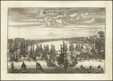
Finely engraved map of Jaffna, in the northern tip of the island of Sri Lanka, from Jacques Nicolas Bellin's Le Petit Atlas Maritime Recueti de Cartes et Plans des Quatre Parlies du Monde en Cinq Volumes, first published in Paris in 1764.
The Portuguese established Jaffna city in 1621 as their colonial administrative center. Prior to the military capitulation to the Portuguese Empire in 1619, the capital of the local Jaffna Kingdom, also known as the Kingdom of the Aryacakravarti was Nallur, which is close to the city limits of Jaffna.
From 1590, Portuguese merchants and Catholic missionaries were active within the Jaffna kingdom. Impetus for a permanent fortified settlement happened only after 1619, when the expeditionary forces of the Portuguese Empire led by Phillippe de Oliveira captured Cankili II, the last native king. Phillipe de Oliveira moved the center of political and military control from Nallur to Jaffnapatao (also Jaffnapattan or Jaffnapattam), the Portuguese rendition of the native name for the former Royal capital.
As shown on the map, Jaffnapatao was a small town with a fort, a harbour, Catholic chapels, and government buildings. Portuguese merchants took over the lucrative trade of elephants from the interior and monopolized the import of goods from Colombo and India, disfranchising the local merchants.
The Dutch were more tolerant towards native mercantile and religious activities than the Portuguese had been. Most of the Hindu temples that the Portuguese had destroyed were rebuilt. The Dutch rebuilt the fort and expanded it considerably. They also built Presbyterian churches and government buildings, most which survived until the 1980s. During the Dutch period, Jaffna also became prominent as a trading town in locally grown agricultural products with the native merchants and farmers profiting as much as the VOC merchants.
The area remained under Dutch control until it was taken by the English in 1796.
Jacques Nicolas Bellin
Jacques Nicolas Bellin (1703-1772) is among the most important mapmakers of the 18th Century.
In 1721, at age 18, he was appointed hydrographer (chief cartographer) to the French Navy. In August 1741, he became the first Ingénieur de la Marine of the Depot des cartes et plans de la Marine (the French Hydrographical Office) and was named Official Hydrographer of the French King.
During his term as Official Hydrographer, the Depot was the single most active center for the production of seac charts and maps, including a large folio format sea-charts of France, the Neptune Francois. He also produced a number of sea-atlases of the world, e.g., the Atlas Maritime and the Hydrographie Francaise. These gained fame, distinction and respect all over Europe and were republished throughout the 18th and even in the succeeding century.
Bellin also came out with smaller format maps such as the 1764 Petit Atlas Maritime, containing 580 finely detailed charts. He also contributed many of the maps for Bellin contributed a number of maps to the 15 volume Histoire Generale des Voyages of Antoine François Prévost or simply known l'Abbe Prevost.
Bellin set a very high standard of workmanship and accuracy, thus gaining for France a leading role in European cartography and geography. Many of his maps were copied by other mapmakers of Europe.
Jacques-Nicolas Bellin (1703-1772) was among the most important mapmakers of the eighteenth century. In 1721, at only the age of 18, he was appointed Hydrographer to the French Navy. In August 1741, he became the first Ingénieur de la Marine of the Dépôt des cartes et plans de la Marine (the French Hydrographic Office) and was named Official Hydrographer of the French King.
During his term as Official Hydrographer, the Dépôt was the one of the most active centers for the production of sea charts and maps in Europe. Their output included a folio-format sea atlas of France, the Neptune Francois. He also produced a number of sea atlases of the world, including the Atlas Maritime and the Hydrographie Francaise. These gained fame and distinction all over Europe and were republished throughout the eighteenth and even in the nineteenth century.
Bellin also produced smaller format maps such as the 1764 Petit Atlas Maritime, containing 580 finely-detailed charts. He also contributed a number of maps for the 15-volume Histoire Generale des Voyages of Antoine François Prévost.
Bellin set a very high standard of workmanship and accuracy, cementing France's leading role in European cartography and geography during this period. Many of his maps were copied by other mapmakers across the continent.
![[Jaffna, Sri Lanka] Jaffenapatnam](https://storage.googleapis.com/raremaps/img/small/76226.jpg)
![[ Taprobana / Sri Lanka ] Duodecima Asie Tabula](https://storage.googleapis.com/raremaps/img/small/101258.jpg)
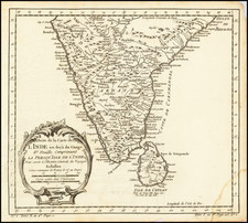
![Hindostan [with inset:] Isle of Ceylon](https://storage.googleapis.com/raremaps/img/small/94596.jpg)