


|
||

|

|
|

|
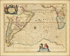
Rare Blaeu Chart of the Caribbean
Rare map of the southeastern part of North America and the West Indies, published in 1634 by Willem Blaeu.
The map was originally issued as the upper left sheet of Blaeu's 4-sheet West Indische Pascaert, issued in 1630. There are only 2 recorded institutional examples of the complete 4-sheet map.
On February 11, 1634, after acquiring a number of maps from the Hondius Family, Blaeu announced the publication of a world atlas in four languages. He was able to complete only the German edition in that year, and was not able to complete all of the maps which he had planned for the atlas. In order to get it ready in time Blaeu used shortcuts in several instances, utilizing portions of his most important separately published wall maps to fill the gaps in the atlas.
While Blaeu planned to release an example of the Hessel Geritsz map of the Caribbean in his Novus Atlas, the copperplate had not been finished. So, for his map of the Caribbean and part of North America, Blaeu used the north western part of the copperplate of his West-Indische Paskaert, covering it on three sides (only on the left is a plate mark visible). Although cleverly disguising the fact by choosing the same left margin, providing a plate mark on one side only, and the Equator as his lower margin, he decapitates a native Indian depiction and slices the cartouche at the top. The title was printed in letterpress on paper and pasted into the remaining half of the cartouche.
This state of the map was first described by Wieder in 1927, who located a single example of the atlas which has since disappeared
The inclusion of the map is a milestone in North American cartographic history, as it represents the first map to focus on the a portion of North America to utilize Mercator's Projection. Blaeu's map of the Atlantic is one of the few contemporary maps to depict the Dutch colonial activities in the New World. It is surmised that the West Indische Pascaert was never offered for general sale to the public, because it lacks a privilege, making this the first generally available example of the map.
The map also represents a remarkable step forward in the mapping of the areas around New York and the Chesapeake, which Blaeu had substantially re-worked from earlier maps and charts. The New England Coastline follows the work of Blaeu's 68 cm globe of 1617. Burden notes that the existence of this map was not re-discovered until 1927. Tony Campbell located a second example in 1984. By the time of Burden's writing, he noted that a total of 7 examples of the map were known in public collections. The present example is one of those located by Burden.
Rarity
The map is very rare. Philip Burden notes that the existence of this map was not re-discovered until 1927 by Wieder. Tony Campbell located a second example in 1984. By the time of Burden's writing, he noted only one example is located in U.S. (Osher collection, University of Southern Maine) and a total of 7 examples worldwide in various institutional collections.
Willem Janszoon Blaeu (1571-1638) was a prominent Dutch geographer and publisher. Born the son of a herring merchant, Blaeu chose not fish but mathematics and astronomy for his focus. He studied with the famous Danish astronomer Tycho Brahe, with whom he honed his instrument and globe making skills. Blaeu set up shop in Amsterdam, where he sold instruments and globes, published maps, and edited the works of intellectuals like Descartes and Hugo Grotius. In 1635, he released his atlas, Theatrum Orbis Terrarum, sive, Atlas novus.
Willem died in 1638. He had two sons, Cornelis (1610-1648) and Joan (1596-1673). Joan trained as a lawyer, but joined his father’s business rather than practice. After his father’s death, the brothers took over their father’s shop and Joan took on his work as hydrographer to the Dutch East India Company. Later in life, Joan would modify and greatly expand his father’s Atlas novus, eventually releasing his masterpiece, the Atlas maior, between 1662 and 1672.
![West Indies and Central America [Bermuda inset]](https://storage.googleapis.com/raremaps/img/small/89941.jpg)
![[ Virginia / Mouth of the Chesapeake Bay ] A Draught of Virginia from the Capes to York in York River and to Kuiquotan or Hamton in James River by Mark Tiddeman](https://storage.googleapis.com/raremaps/img/small/103814.jpg)