


|
||

|

|
|

|
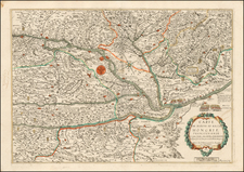
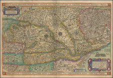
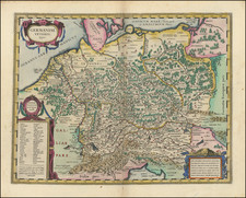
Claes Janszoon Visscher Edition of the Claes/Van Duetecum Map of Hungary
Important early map of Hungary, centered on the course of the Danube River, from Hungary to Romania, published by Claes Janszoon Visscher in 1624.
The map was first published by Cornelis Claesz in 1596.
The map extends from Maribor, Zagreb and Vienna in the west, to Sibiu, Pitesti and Fagaras in Romania. A double headed eagle in the middle bears the arms of Hungary. The map includes small coats of arms, bird's eye views of the cities and descriptions of the important battles. The sign in the lower cartouche explains that the towns conquered by the Ottomans are marked with a crescent on the top and the Christian towns with a cross.
States of the Map / Rarity
Engraved by Joannes Van Deutecum, the map appeared in the following states:
- State 1: 1596 by Cornelius Claesz
- State 2: 1619 by Davit de Meijne
- State 3: 1620 by Pieter Van Den Keere
- State 4: 1624 by Claes Jansson Visscher
- State 5: 1634 by Claes Jansson Visscher
State 1, 2 and 3 are extremely rare. States 4 and 5 are a bit less rare.
![(Italy and Austria) Carta geografica statistica postale dell’I.R. Monarchia Austriaca e dell’Italia [Statistical postal geographic map of the Imperial Royal Austrian Monarchy and of Italy]](https://storage.googleapis.com/raremaps/img/small/94038.jpg)