|
||

|

|
|

|
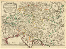
Original antique 17th-century map of Tyrol, by Jan Jansson, showing the region on the border between Italy and Austria. The map stretches from the Bodensee in the northwest to Saltzburg in the northeast, down to the Italian foothills near Trent in the south.
The map is richly colored and detailed, showing the imposing mountains pictorially and naming forests and other geographical features. The map includes two decorative cartouches.
The region of Tyrol, which now encompasses three states spread across the Austrian-Italian border, was once ruled by the great Counts of Tyrol in the Middle Ages, which established its independent nature. Eventually, the region was agglomerated into the Hapsburg Empire. It remained as part of this entity until Italian unification in the 19th century.
This map was engraved by Johan Jansson in Amsterdam in the middle of the 17th century.
Jan Janssonius (also known as Johann or Jan Jansson or Janszoon) (1588-1664) was a renowned geographer and publisher of the seventeenth century, when the Dutch dominated map publishing in Europe. Born in Arnhem, Jan was first exposed to the trade via his father, who was also a bookseller and publisher. In 1612, Jan married the daughter of Jodocus Hondius, who was also a prominent mapmaker and seller. Jonssonius’ first maps date from 1616.
In the 1630s, Janssonius worked with his brother-in-law, Henricus Hondius. Their most successful venture was to reissue the Mercator-Hondius atlas. Jodocus Hondius had acquired the plates to the Mercator atlas, first published in 1595, and added 36 additional maps. After Hondius died in 1612, Henricus took over publication; Janssonius joined the venture in 1633. Eventually, the atlas was renamed the Atlas Novus and then the Atlas Major, by which time it had expanded to eleven volumes. Janssonius is also well known for his volume of English county maps, published in 1646.
Janssonius died in Amsterdam in 1664. His son-in-law, Johannes van Waesbergen, took over his business. Eventually, many of Janssonius’ plates were sold to Gerard Valck and Pieter Schenk, who added their names and continued to reissue the maps.
![(Austria) Charte der Österreichischen Monarchie, nach den letzten Friedensschlüssen berichtigt. [Map of the Austrian Monarchy, corrected according to the latest peace treaties.]](https://storage.googleapis.com/raremaps/img/small/102892.jpg)
![Stato Di Milano Parte Occidentale [and] Stato Di Milano Parte Orientale](https://storage.googleapis.com/raremaps/img/small/94602.jpg)