|
||

|

|
|

|
Plancius’ Extremely Rare Map of France—Previously Unrecorded Interim State!
Fine, and exceedingly rare, early map of France, drawn by Petrus Plancius, engraved by Baptista van Doetecum, and published by Cornelis Claesz in Amsterdam in 1592. This is a previously unrecorded interim state, dated to 1592.
While the map is very similar to the map of the same title which first appeared in the 1606 edition of Ortelius' Theatrum Orbis Terrarum, published by J.B. Vrients, the present map is actually printed from an entirely different, earlier, and more finely-wrought, copper plate. It is the first edition of the map to have been published, but with additional information as compared to the first state.
This example has only the attributions to Plancius, as the author, and van Doetecum. Other, later, examples of the first edition, including this one at the Maritime Museum, Rotterdam, carry an additional attribution to Vrients. As Schilder notes, the second state also has added lakes near Utrecht, as well as additional dotted lines around polities, for example near Vastenou. The example under examination here has these additions, but does not have the attribution to Vrients. This is the only known example with these characteristics, an interim between the first and second states of the first edition.
The map was published in Amsterdam by Claesz, who had a close working relationship with Plancius and Doetecum. In 1592, Claesz enjoyed a twelve-year privilege for a series of maps from the States General. The map is mentinoed in Claesz's Const end Caert-Register (1609), as well as in the Catalogus Auctorum in Ortelius' Theatrum Orbis Terrarum. It was also sold by Vrients in Antwerp in a second state with his name attached. This example, therefore, is an interim state of the first edition.
Plancius was known for his close, refined review work of as many sources as were available to him—and many of those sources were exclusive to his workshop, thanks to his wide and rich network of geographical contacts spread across Europe and the wider world. This map is no exception. Meurer and Schilder note that it loosely follows the 1570 map of France by Postel and the similar, yet scarcely recorded, Ortelius reduction of the same, but it is an improvement on both. It covers a wider geographic area, extending considerably to the north and adding more coverage of the Low Countries. While all states and editions of this map are rare today, it was influential at the time and was reproduced in Ortelius’ Theatrum Orbis Terrarum, the first modern atlas, from 1606.
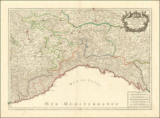
The map frames France with the Low Countries, Northern Italy, the Spanish Pyrenees, and the southern half of the British Isles. The countryside is thickly labeled with towns, cities, monasteries and religious sites, rivers, and regional names.
Editions and states of the map
This map is an interim state of the first of several editions which were published from 1592 to at least 1606. Each edition was re-engraved on a new plate of a slightly different size.
The first edition (407 x 502 mm) has the date 1592 and credits Baptista van Doetecum in the title cartouche. It was separately issued. A second state of this first edition also features Vrients’ name.
Some printings of this edition were included with John Eliot’s The suruay or topographical description of France (London: John Wolfe, 1592), which advertised, “a new mappe, helping greatly for the surueying of euery particular country, cittye, fortresse, riuer, mountaine, and forrest therein.” However, only one known surviving example of the booklet includes the map, that of Cambridge University Library.
The second edition (390 x 475 mm) has “Mauricii Boguerealdi. Cum privilegio regis 1593” included in the title cartouche. It appears in Bouguereau’s Theatre Francoys (1594), one of several maps of France in the atlas. It is a close copy of the first edition, repackaged for the French market, as the atlas was published in Tours. The atlas continued under the publication of Jean le Clerc after Bouguereau's death (1596), but with the new title of Théâtre géographique du Royaume de France. This atlas appeared in six editions, with the second edition of the map appearing in the first (1619), second (1620), and third (1621) editions.
A third edition was published in 1600 by Paul de la Houve (39.5 x 48.5 cm, according to Schilder). De la Houve, who was from Antwerp but worked in Paris, made his own copy of the Plancius map with Plancius' name removed. The decorative elements are quite different, however, with a smaller cartouche and two portraits--of Queen Maria de Medici (top right) and King Henry IV (top right)--inserted. There is also a later (1647) anonymous English reworking of this plate, entitled, "A mapp of France Newly Reuiued."
The fourth edition (400 x 486 mm) cites Vrients (first state, 1606) and later Theodor Gallaeus (second state, 1612). This edition also spells Plancius' name as Plantio, rather then Plancio. The first state was included in re-issues of Ortelius’ Theatrum Orbis Terrarum. The second state was published separately. It is possible that something happened to the first Dutch plate, possibly when it was in England or being used to print copies for the Eliot booklet, forcing Vrients to have this one re-engraved.
A fifth edition is only sparsely known, as Schilder explains. This edition was skillfully made by the otherwise unknown engraver Hermanus Mertens, and the place of publication is also a mystery (39.5 x 48 cm, according to Schilder).
General differences between all the plates can be seen in the decorations of the cartouche, the stippling of the water, and especially in the shape of the hills just below the cartouche.
Rarity
The map is very rare. We trace no offer of either the first or second edition of this map, in any state, on the market in the past three decades.
There are only two known examples of the first state of the first edition. The known examples are at Cambridge University Library (with the Eliot booklet) and the Bodleian in Oxford. Schilder notes an example of this state at the Huntington, with the Eliot booklet, but librarians recently confirmed that this example is not extant.
According to Schilder, there are five extant examples of the second state of the first edition, at the British Library, the Royal Geographical Society, the Niedersächsische Landesbibliothek (Hannover), the Biblioteca Narodowa (Warsaw), and the Maritime Museum in Rotterdam.
Of the second edition, dated 1593, we locate two examples in two copies of Bouguereau’s Theatre Francoys (1594) held by the British Library, as well the two examples at the Bibliothèque de l'Arsenal (Paris) and the Herzog August Bibliothek (Wolfenbüttel), noted by Schilder, and an unconfirmed example in Stuttgart.
The third edition is held by Det Kongelige Bibliotek (Copenhagen) and the BNF.
Of the fourth edition, which appeared in Theatrum Orbis Terrarum from 1606, there are examples in several institutional collections, including the British Library, the Maritime Museum of Rotterdam, the Newberry Library, and elsewhere. This edition also has a second state; it has the signature of Theodor Gallaeus instead of Johannes Baptista Vrients as the engraver cited (Doetecum is not mentioned in either state). Examples of the second state are held at the BNF and elsewhere.
The fifth edition is thought to survive in only one example, at Det Kongelige Bibliotek (Copenhagen), although an example was supposed to have been in the former Armeebibliothek in Munich, which was destroyed in WWII.
Petrus Plancius (1552-1622) was born Pieter Platevoet in Dranouter in West Flanders. He trained as a clergyman in Germany and England, but he was an expert not only in theology but in geography, cosmography, and navigation. After fleeing prosecution by the Inquisition in Brussels, Plancius settled in Amsterdam where he first began his forays into navigation and charting. As Amsterdam was a hub for trade, Plancius was able to access Portuguese charts, the most advanced in the world at that time. Plancius used these charts to become an expert in the sailing routes to India, knowledge that gained him opportunity. Plancius was one of the founders of the VOC, for whom he worked as their geographer. He also served on a Government Committee to review the equipment needed for exploratory expeditions.
![[Battle of Moncontou] Victoria di chatolici contra Hugonoti](https://storage.googleapis.com/raremaps/img/small/75053.jpg)