|
||

|

|
|

|
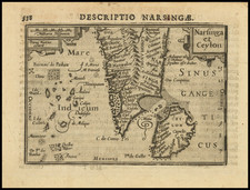
Very scarce antique map showing the island of Sri Lanka and engraved in a marvelously mythical style. The map shows a great many sea monsters, mountain ranges, great pagodas, and Hindu gods and was originally published by Theodor De Bry in part seven of his India Orientalis at the start of the 17th century.
The map names Sri Lanka by an uncommon and unusual bastardization of Ceylon, its former European name. Numerous cities are shown, including many which never existed, although Columbo is shown in the right locale, as is Negombo. The mountains of southern Sri Lanka are named the Pica Dadani.
This map appeared as one of two maps in this notably uncommon De Bry volume, with the other focusing on the city of Candy. De Bry's maps are often notable for their legend-focused outlooks, and they often contain numerous sea monsters and mythical creatures. De Bry's works covered the newly discovered parts of the world, with a special focus on the Americas and Southeast Asia.
States
This is the first of two states that we were able to identify, with the cartouche left blank. The map is dated in the cartouche.
Theodor de Bry (1528-1598) was a prominent Flemish engraver and publisher best known for his engravings of the New World. Born in Liege, de Bry hailed from the portion of Flanders then controlled by Spain. The de Brys were a family of jewelers and engravers, and young Theodor was trained in those artisanal trades.
As a Lutheran, however, his life and livelihood were threatened when the Spanish Inquisition cracked down on non-Catholics. De Bry was banished and his goods seized in 1570. He fled to Strasbourg, where he studied under the Huguenot engraver Etienne Delaune. He also traveled to Antwerp, London, and Frankfurt, where he settled with his family.
In 1590, de Bry began to publish his Les Grands Voyages, which would eventually stretch to thirty volumes released by de Bry and his two sons. The volumes contained not only important engraved images of the New World, the first many had seen of the geographic novelties, but also several important maps. He also published a collection focused on India Orientalis. Les Grands Voyages was published in German, Latin, French, and English, extending de Bry’s fame and his view of the New World.
![(Jaffna, Sri Lanka) Ein Prospect Castells Jaffnapatnam, wie sich daslelbe uber das Wasser gegen das Thor, der Compagnie Stall, u werff praessentiret [A view of the castle of Jaffna, as it appears from the water towards the gate, the Company stable, and the rampart.]](https://storage.googleapis.com/raremaps/img/small/0109gh.jpg)
![[Sri Lanka] A Map of the Coast of Coromandel from the River Gadevari, to Cape Comorin](https://storage.googleapis.com/raremaps/img/small/62976.jpg)
![[Taprobana / Sri Lanka] Asiae XII. Tab.](https://storage.googleapis.com/raremaps/img/small/89180.jpg)