


|
||

|

|
|

|
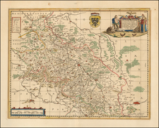
First State of Zaltieri's Map of Bohemia
Rare separately issued 2 sheet map of Bohemia, first published by Zaltieri and later re-issued by Rascicotti.
This is the only Lafreri school map of Bohemia. It almost certainly pre-dates 1568, when Johann Criginger produced a map of the region which was copied shortly thereafter by Ortelius and De Jode in Antwerp.
This rare map is based on the Mikulas Klaudyan (Mikuláš Klaudyán) map of Bohemia from 1518 (more commonly known as the Nicolaus Claudianus map of Bohemia), one of the earliest surviving "modern" maps of a region in Northern Europe. The original Claudianus map survives in one example in Litoměřice Episcopal Library. The following has been written about this map by Peter Meuer.
In 1518, the Nuremberg printer Hieronymus Höltzel, also an early supporter of the Reformation, produced a political leaflet that included the first map of Bohemia. Its author was the Czech physician and humanist Nicolaus Claudianus (Mikolas Kulha), a member of the Bohemian Brethren.
The topographically rich and accurate map was entirely based on the author’s personal knowledge; technical influences of the Etzlaub maps are visible in the orientation to the south. Particular emphasis was given to a detailed differentiation between royal and feudal and between Catholic and Utraquist settlements.
The map may have been prepared for the purpose of showing the distribution and status of Papal and Hussite adherents.
Zaltieri's map is topographically similar to the Claudianus map and the nomenclature is the same, but the typography differs from the original. The title in Italian given at the bottom right is:
A' lettori. Eccovi la Boemia di nuova minutamete descritta co tutte le sue Citta, Castelli et Vile. Ella e come sid vede tutta circondata di Monti et di Selve, et dal fiume Albi nel piu bagnata. La Citta principale en ess e Praga. E' sottoposta all casa d'Austria.
There are two states of the map.
- State 1: Zaltieri imprint
- State 2; Imprint of Donati Rascicoti, 1619 added to "A'lettori section at lower right.
The title block in Italian (same meaning as the Latin at the top left) at the bottom right translates as follows:
A’lettori. Eccovi la Boemia di nuovo minutame[n]te descritta, co[n] tutte le sue città, Castelli, et ville. Ella p[er] come si vede tutta circo[n]data di Monti, et di Selve, et dal fiume Albi nel più bagnata. La Citta principale in essa e Praga. E’sottoposta alla casa d’Austria.
Here is Bohemia again described in detail, with all its cities, castles, and villas. As it is seen, it is all surrounded by mountains and forests, and by the river Albi in the wettest. The main city in it is Prague. It is submitted the Austrian house.
Rarity
One of the rarest of all maps of Bohemia as it has been only once on auction in the past 40 years (Christies, 2000).
We have previously offered the map once in 2020 and the Rascicoti once on 2015.

![[ Holy Roman Empire ] Nova Totius Germaniae Descriptio Geographica](https://storage.googleapis.com/raremaps/img/small/95672.jpg)
![[ Holy Roman Empire ] A Newe Mape of Germany Newly Augmented by Iohn Speed Ano Dom: 1626](https://storage.googleapis.com/raremaps/img/small/68482.jpg)