|
||

|

|
|

|
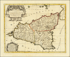
An Important Early Lafreri School Map of Sicily
Rare separately published map of Sicily, based upon Giacomo Gastaldi's map of the island published in 1545.
While the details of this version's origin are somewhat mysterious, it is a very elegant interpretation of Gastaldi's work, depicting the island's mountainous topography, highlighted by the form of Mount Etna (Mongibello). The seas are filled with merchant ships and Roman triremes.
States of the Map
- State 1: No publisher or date
- State 2: Signature Pauli Gratiani Formis Romae 1582 added at the top.
- State 3: Signature Petri de Nobilibus Formis added at the bottom left.
- State 4: Signatures erased. With new signature of Baptista Cavale.ris Formis Romae 15.
- State 5: Signature of Gio. Giacomo de Rossi added
Rarity
We note two examples at auction in the past (1998 and 2006). We believe this is the 2006 Christies example, as it was acquired with the Licinius map of Sardinia, which was also in the Christies sale lot.
The Lafreri School is a commonly used name for a group of mapmakers, engravers, and publishers who worked in Rome and Venice from ca. 1544 to 1585. The makers, who were loosely connected via business partnerships and collaborations, created maps that were then bound into composite atlases; the maps would be chosen based on the buyer or compiler’s interests. As the maps were initially published as separate-sheets, the style and size of maps included under the umbrella of the “School” differed widely. These differences can also be seen in the surviving Lafreri atlases, which have maps bound in with varying formats including as folded maps, maps with wide, trimmed, or added margins, smaller maps, etc.
The most famous mapmakers of the School included Giacomo Gastaldi and Paolo Forlani, among others. The School’s namesake, Antonio Lafreri, was a map and printseller. His 1572 catalog of his stock, entitled Indice Delle Tavole Moderne Di Geografia Della Maggior Parte Del Mondo, has a similar title to many of the composite atlases and thus his name became associated with the entire output of the larger group.
Antonio Lafreri (1512-1577) (also known as Antoine Lafréry and Antoine du Pérac Lafréry) was a French mapmaker, engraver, and publisher who worked in Italy. Lafreri was born in Franche-Comté and moved to Rome around 1540. Lafreri sold sheet maps but he also bound maps into books for his clients based on their interests and needs. These are the famous Lafreri atlases, important pre-cursors to the modern atlas. He also published well known works such as the Speculum Romanae Magnificentiae (ca. 1575), a collection of engraved views and images of Rome. Lafreri was well-connected to the cartographic networks of the time, collaborating with Giacomo Gastaldi, Battista Agnese, Antonio Salamanca, Donato Bertelli, Paolo Forlani, and others.
![[ Kingdom of Sicily, with Malta ] Carte De L'Isle Et Royaume De Sicile. Par Guillaume Delisle de l'Academie R. des Sciences. À Venise par P. Santini 1779.](https://storage.googleapis.com/raremaps/img/small/102161.jpg)
![[Sicily] Li Nomi Antichi e Moderni De l'Isola d'Sicila](https://storage.googleapis.com/raremaps/img/small/43268.jpg)