|
||

|

|
|

|
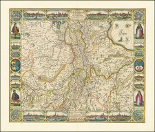
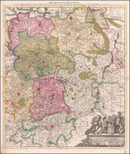
Single sheet from Jan Jansz. Dou and Steven van Broeckhuijsen's 12 sheet monumental wall map of the Holland, published in Amsterdam, under the title 't Hooge Heemraad-Schap van Rhijnland.
This map was utilized to record the location of the many canals and land owners in the region depicted, in order to allow the water board to assess taxes and make other decisions. In order to be able to protect the lower area in Holland against the sea and rivers, there were several water commissions in West-Netherlands responsible for the management and care of the territory.
Dou's map is generally considered the best of the water board maps. Koeman notes:
Obviously South Holland has also had its big names in waterschapskartografie of the 17th century. Among those names dominates that of Jan Jansz. Dou, the surveyor of Rhineland and his colleague Steven Broeckhuysen. Their large map (...) is rightly regarded as the "non plus ultra" of Dutch water board mapping from the 17th century (...) the large scale [1: 30.000]. admitted the full view of the habitation: not just the outposts but all farms and other buildings along the roads. irreplaceable information about the infrastructure of the densely populated area of the Netherlands in the Golden Age.