|
||

|

|
|

|
Exceedingly Rare First Dutch Sea Chart of Sicily and Malta, From the First Sea Atlas of the Mediterranean
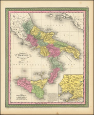
Very rare original antique map of the central Mediterranean, encompassing Calabria, the southern part of Sardinia, and the Tunisian coastline. This map appeared in William Barentsz's important Caertboeck Vande Midlandtsche Zee, first published in Amsterdam in 1595.
This map represents the earliest printed navigational chart of this area, drawing on previous Italian portolan charts. Highly decorated in a manner that shows the cooperation between Barentsz, Claesz, and Petrus Plancius, another important Low Countries cartographer, the map is replete with numerous sailing ships and sea monsters. Two compass roses appear with associated rhumb lines. The map also includes two cartouches, one with the title and one with a scale bar.
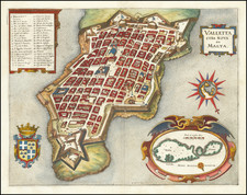
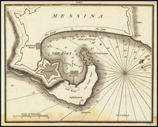
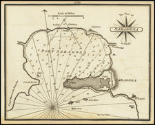
This map, while produced for navigational purposes, shows inland detail, with many cities named. Sicily is shown in full detail, with dozens of towns named. At the top of the map are four stunning insets, showing Palermo, Messina, and Trapani. The port of Valletta in Malta is shown, less than a century after the building of the city of Valletta on the Sciberras by the Knights Hospitaller. The city would be mostly complete by 1570s and declared capital of Malta in 1571.
The map is extremely decorative reflecting Plancius's decorative influence on Barentsz. Containing three compass roses, the same number of cartouches, six sailing vessels, and four sea monsters, this really is a marvelous map.
This map appeared in the very rare French edition of the Caertboeck.
Caertboeck vande Midlandtsche Zee
Barentsz's Caertboeck, published by Claudius Claesz, represents the first printed navigational atlas of the Mediterranean. Containing nine charts of regions of the Mediterranean, as well as one Portolan chart of the whole sea, the atlas was based on a number of early sources including Italian, Spanish, and Portuguese portolans as well as the travels and accumulated knowledge of Barentsz and other Dutch pilots. The atlas represented a stark contrast to earlier Dutch navigational atlases, which relied primarily on coastal views and only the most basic maps.
This atlas was first printed in 1595 as its principal cartographer, Barentsz, was embarking on his ill-fated voyages that attempted to find a northern passage to China. The atlas was printed a number of times later, with the last edition in appearing 1654 after the plates passed to Jansson.
Note on the Compass Roses
Two of the three compass roses show declinations that vary by just under six degrees. One is for a "ghemenye" compass, used in northern European waters, and is set for the magnetic variation in Northern European waters. The other two, made for Italian compasses, is set for Mediterranean waters and shows the variation for that part of the world. These two compasses simplified navigation, so that sailors did not have to constantly correct for variations.
It is very unusual to see both compasses on the same map.
Rarity
This map is very rare. It is the first time we have offered it for sale (although we have previously had a much later reprint), and we find no prior evidence of it having been on the market. RBH lists one example as having sold in the last 20 years. In addition, the database lists only one complete example of the atlas coming up at auction in the past 50 years.
![[Palermo -- Certificate of Good Health Upon Entering Port of Palermo] Noi il Senato De Ela Felice Fedelissima Citta di Palermo Capitale del Degno di Sicilia...](https://storage.googleapis.com/raremaps/img/small/84431.jpg)
![[Composite Lafreri-style Atlas of Battle Plans and Fortifications]](https://storage.googleapis.com/raremaps/img/small/92702.jpg)