|
||

|

|
|

|
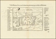
Rare 1644 Gravelines Broadside
Rare broadside battle plan and account of the Siege of Gravelines, published in Amsterdam by Cornelis Danckerts.
The map is oriented with south at the top and includes a text account of the Siege in both French and Dutch.
Includes a map of the area, birdseye view of the fortified city and coat of arms. The plan provides a view of the Siege in minute detail including troop encampments and movements, fortifications, canals and the Dutch fleet in the sea.
The map was later copied by Joannes Blaeu.
Siege of Gravelines
The 1644 Siege of Gravelines took place during the 1635 to 1659 Franco-Spanish War. A French army captured the port of Gravelines, then in the Spanish Netherlands, now the Pas-de-Calais region of northern France.
Siege operations began on May 28, 1644 and the town surrendered on July 28, 1644. Recaptured by the Spanish in 1652, it changed hands again in 1658 and was ceded to France in the 1659 Treaty of the Pyrenees.
Rarity
We locate a single example of the map and text at the Sachsiche Landebibliothek.
![Montes, Hannoniae Metropolis [and] Atrebatum, Episcopalis Et Metropolica Artesiae Citivas](https://storage.googleapis.com/raremaps/img/small/41468mp2.jpg)
![Carte du Pays et Diocese de Reims [Map of the Country and Diocese of Reims]](https://storage.googleapis.com/raremaps/img/small/67548.jpg)
![[English Channel] A New Gradnally Encreassnig Compass-map of the Comingin of the Channel, or the Heads; containing a part of the coast of Boulonnois; extending from Callis to Dannes, as also in England, from the South Foreland to Rye; with their S'hallownesses and Depths By N. deVries](https://storage.googleapis.com/raremaps/img/small/85127.jpg)