


|
||

|

|
|

|
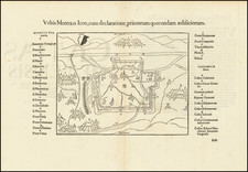
Metellus's Map of His Home Region.
Very rare map of Burgundy, published by the fascinating Cologne-school cartographer Johannes Metellus. Showing fine, early detail of this French-wine producing region in the northeast, rivers, forests, cities, roads, and more are all shown.
The Cologne School of engraving, a one-time rival to the Amsterdam map publishers, created some of the rarest and most intriguing maps of the day, drawing their knowledge from the great German universities that lined the Rhine River. Their almost-Lafreri like design for hills, and delicately engraved trees are both visible on this map.
This map shows the city of Besancon and other cities along the Rhine River. The Saone is named in the top of the map, orientated the top to the northwest. The map includes an attractively designed classical cartouche, with its title in three languages - common for Metellus's maps.
Johannes Matalius Metellus, also known as Jean Matal or Johannes Metellus Sequanas, was born in Poligny, Burgundy, France in ca. 1517. A humanist scholar, he was a polymath devoted to cartography, geography, law, paleography, and antiquarianism. Late in life he published a series of atlases; all his maps and atlases are rare and highly sought-after.
Matal was educated at Dole, Freiburg, and several Italian institutions. At Bologna, he met Antonio Agustín, a Spanish legal scholar, who recruited Matal to be his secretary. Together, the men researched ecclesiastical law, with an especial emphasis on Roman legal manuscripts, with trips to Venice, Florence, and elsewhere in Italy to study codices. In 1555, the two traveled to England to meet with Queen Mary on a mission for the Church.
After leaving his employment with Agustín, Matal traveled in the Low Countries and eventually settled in Cologne. There, he mixed with other savants, including especially Georg Cassander and Pedro Ximénez. It was in Cologne that Matal began his serious interest in mapmaking. He contributed to Braun and Hogenberg’s Civitae Orbis Terrarum; Georg Braun described him in glowing terms, “vir omni scientiarum genere praestans"—"a man outstanding in every form of knowledge."
Late in life, Matal began preparing a set of maps of the entire world. In 1594, he published an atlas of France, Austria, and Switzerland (39 maps), in 1595 an atlas of Spain (10 maps), and, posthumously, an atlas of Italy (37 maps), and one of Germany and the Netherlands (55 maps). Many of these maps were combined and augmented into atlases of Europe, Asia, Africa, the Americas, and the world’s islands. In 1602, a compendium work showcased all of these previous works called Speculum Orbis Terrae; this atlas was well received by contemporaries like Walter Raleigh and is very rare today. Many of these maps and atlases were released after his death in 1598, they were finished by his friend and fellow mapmaker Conrad Loew (Matthias Quad).
![[ Joinville ] Pourtraict ou Plan de la Ville de Ionville](https://storage.googleapis.com/raremaps/img/small/74272.jpg)
![(Sainte-Marie-aux-Mines, France) Von dem Teutschenland. ccclxxxiii. Namen der Gruben [im Furtelbach.] .](https://storage.googleapis.com/raremaps/img/small/78332.jpg)