
This item has been sold, but you can enter your email address to be notified if another example becomes available.


|
||

|

|
|

|
Stock# 75477
Description
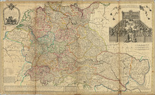
Map of eastern Brabant, centered around the Meierij van 's Hertogenbosch, or Bailiwick of Bois-le-Duc, tetrarch. It was likely published before Visscher's death as there is no additional attribution.
The County of Megen is to the north, Duchy of Cleves to the northeast, the Duchy of Gelder to the northeast and east, the Bailiwick of Herentals to the southwest, the Barony of Breda to the west, and the County of Holland to the northwest. Bommel, Heusden, 's Hertogenbosch, Eynihoven, Helmont, Graaf, Cranenburg, and Gennep are featured as major cities and highlighted in red.
Condition Description
Original hand-color. Two 1/4" diameter holes in upper portion, in legend at left and scale at right. In green areas, cracking has created a hole in 't Land van Kuyk and 4 holes in Kempenland, a tape repair on front to left of centerfold, and some loss at the bottom. Some foxing.
![[Holland] Holad](https://storage.googleapis.com/raremaps/img/small/78197.jpg)
![[ Belgium ]. Les Provinces des Pays-Bas Catholiques ou a Most Exact Map of Flanders or ye Austrian Netherlands &c. . . .](https://storage.googleapis.com/raremaps/img/small/102631.jpg)