|
||

|

|
|

|
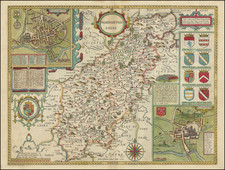
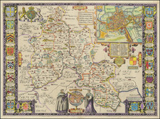
Beautiful example of the first state of Christopher Saxton's famous county map of central Wales, covering modern-day Cardiganshire, Radnorshire, Brecknockshire, and Carmarthenshire.
The shows the Irish Sea at the west and the Bristol Channel at the south. Four large mountains are illustrated (along with many smaller ones), Saxton labels them "Monuchdennye hil", "Plinillimon Hill", "The black mountayne", and "Wrenyuawre hill".
The map was the product of Saxton's survey of England, which he commenced in 1574. Despite the arduous and groundbreaking nature of the surveying work, the first plates were already being made in 1574 and the work was complete in 1578. Some have suggested that Saxton relied on John Rudd's earlier surveys to speed up this process.
The products of Saxton's survey, including the present map, originally appeared in Christopher Saxton's Atlas of the Counties of England and Wales (1579), the first English county atlas. That atlas was made possible through the sponsorship of Queen Elizabeth and William Cecil, Lord Burghley, Elizabeth's chief adviser. Thomas Seckford, who commissioned the survey from Saxton, is honored on a number of the maps with his coat of arms. This map has his arms in the lower-left along with his motto "Industria Naturam Ornat".
At the bottom edge on the right is a scale of miles and a banner identifying Saxton as the author of the map.
Saxton used three named engravers for the Atlas though none of their names appear on this work.