|
||

|

|
|

|
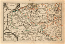
Original, antique map of the French-Belgian border, published at the end of the 17th in Amsterdam by the important mapmaker Frederick De Wit.
Engraved in an expert manner, this decorative map shows the cities of the region including Mons, Charleroi, Maubeuge, and Valenciennes. The course of the Sambre River is shown. Many forests, roads, towns, rivers, and other features throughout the map appear.
The map includes several decorative elements, including a cartouche with a coat of arms in the upper right and a scale bar flanked by cherubs in the center left.
De Wit (1629 ca.-1706) was a mapmaker and mapseller who was born in Gouda but who worked and died in Amsterdam. He moved to the city in 1648, where he opened a printing operation under the name of The Three Crabs; later, he changed the name of his shop to The White Chart. From the 1660s onward, he published atlases with a variety of maps; he is best known for these atlases and his Dutch town maps. After Frederik’s death in 1706, his wife Maria ran the shop for four years before selling it. Their son, Franciscus, was a stockfish merchant and had no interest in the map shop. At the auction to liquidate the de Wit stock, most of the plates went to Pieter Mortier, whose firm eventually became Covens & Mortier, one of the biggest cartography houses of the eighteenth century.
![[Calais] Chales](https://storage.googleapis.com/raremaps/img/small/61280sb.jpg)