
This item has been sold, but you can enter your email address to be notified if another example becomes available.


|
||

|

|
|

|
Stock# 75431
Description
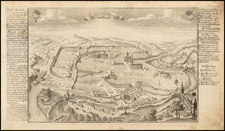
An Exceptional Woodblock Printed Map of Western Eruope
Rare map centered on France and covering signficant portions of Germany the Low Countries and the English Channel, from Stumpf's Schweytzer Chronick.
The map is oriented with south at the top and includes several large coats of arms, smaller regional coats of arms, an elaborate saling ship and sea monsters.
States
The map can be identified as being of the 1548 (some sources say 1554) printing of the Chronick, and not of the 1586 or 1606 printings due to the typography of the text at the top. The "G" in Galliae has a rigid left end, while later editions have a more rounded start to the letter.
Condition Description
Reinstatement of lower left corner, not touching the image. Apprx. 2 by 3 inches.
![(Geological Map of France) Carte Geologique de la France [4 sheets]](https://storage.googleapis.com/raremaps/img/small/93799.jpg)
![[Napoleon's Battles in France, Belgium Netherlands, Luxembourg, Germany] No. 1 Frontiere du Nord. Mesny 5.](https://storage.googleapis.com/raremaps/img/small/60727.jpg)
![[ Postal Map of Eastern Europe ] Deutschlands Postkarte begraenzt von Oesterrreich, Preussen, Frankreich, Holland, Italien und der Schweiz. Gezeichnet und Herausgegeben von Ignaz Heymann. K.K. Obserpostamtsoffizier in Trieste. 1800.](https://storage.googleapis.com/raremaps/img/small/77678.jpg)
![(Germany) [Sketch and Albumen Print Album / Travels Along the Rhine River, including Nuremberg] Reis langs den Ryn Frankfort, Heidelberg, Munchen, Weenen, Tyrol, Salzburg, Dresden en de Sachsische Schweiz](https://storage.googleapis.com/raremaps/img/small/89724.jpg)