


|
||

|

|
|

|
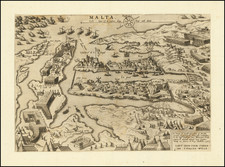
"Nothing Is More Well Known Than the Siege of Malta" –Voltaire
Rare and highly-informative news map of the Siege of Malta, made by the master engraver Hieronymus Cock in Antwerp in 1565. This was the only map of the siege issued in the Low Countries.
The map shows the Knights Hospitaller besieged in the Grand Harbor in eastern Malta. The Knights had arrived thirty years earlier, after losing their previous stronghold of Rhodes to the Ottomans. They quickly set to work fortifying the tiny, yet strategically located, island, especially because there were reports in 1564 of Ottoman forces massing for a siege attack. The siege came in May 1565, lasting sixteen weeks until September of that year.
The map illustrates the Ottoman forces attacking the Knights’ positions at Fort St. Angelo, at the tip of Birgu (here called Borgo) and Fort St. Michael on the Senglea peninsula. Ottoman soldiers are shown with turbans and flags bearing the crescent moon. Both of these promontories are highly developed, with the Knights’ new capital city on Birgu and windmills turning on Senglea. The port is between them, blocked off with chains to prevent enemy ships from sailing in. Trenches have been dug separating the peninsulas from the mainland, where the main Turkish encampment is based. Just south are burning boats, lit by the Knights and causing some Turkish soldiers to flee.
To the northwest is Mount Sceberras, which is now the location of the capital city, Valetta. At its tip is Fort St. Elmo, which is being flooded with Ottoman troops. This occurred on June 23, 1565. Further back from the waterfront, huge columns of the Sultan’s troops are marching toward Birgu. The Knights’ situation appears dire, surrounded as they were on three sides.
The map bears the date October 24, 1565, showing how quickly news of the siege reached northern Europe. Ganado estimates that it took three to four weeks for news maps of the siege to appear on the market in Rome and Venice, where most maps of the event were produced. Additional weeks have to be added to this estimate for northern European cities likes Antwerp.
This map is loosely based on a map made several months earlier by Roman mapmaker Mario Cartaro and published on June 20. Cock has vastly updated Cartaro’s work on a new plate, adding the latest news from the front, including the taking of St. Elmo, which is not yet under attack in Cartaro’s print. Cock’s work is also much livelier in its engraving than the Cartaro prototype.
All of Europe’s eyes were turned on Malta in 1565; losing the island would represent the major loss of both a Christian stronghold and a strategic military linchpin in the lucrative Mediterranean. As Maier explains, the Siege spawned the largest number of news maps for any military engagement to that date. It was “part of a media event unprecedented in the sheer quantity and scope of materials produced, all of which sought to sway public perceptions of the episode and to keep Europeans on the edge of their proverbial seats” (461-2). Soon after this map was published the news of the successful repulsion of the Ottomans would have reached Antwerp.
The Siege of Malta
Emperor Charles V, with the approval of Pope Clement VII, granted the Maltese archipelago to the Knights of St. John in 1530, after the Knights had lost Rhodes to the Ottomans in 1522. The Knights quickly moved to increase the fortifications of the island, as it too was under threat from an Ottoman invasion or siege. Indeed, the Ottomans tried to take Malta in 1551. Upon failing to take Birgu and the inland capital of Mdina, the corsairs turned to neighboring Gozo and captured practically the entire population.
In response, the Knights began construction on Forts St. Michael and St. Elmo and moved their capital to Birgu. In the autumn of 1564, both the Papacy and Jean de Valette, Grandmaster of the Knights, heard rumors that the Ottomans had again set their sights on Malta.
They arrived on May 18 in over 200 ships commanded by Piali Pasha. The ships carried a huge number of troops, estimated at between 20,000 and 40,000 men. The Knights commanded fewer than 6,000 men, most of them local Maltese and with only 500 Knights. The Ottomans landed at Marsaskala, to the southeast, and marched overland to Marsa, at the base of Mount Sceberras. The siege was on.
The Ottomans focused their efforts on Fort St. Elmo, as they reasoned that if they could take that fortification on the high ground, they could then bombard the port into submission. Taking St. Elmo from its 600 defenders proved difficult, however, with the Ottomans facing a mounting number of casualties. In the meantime, the Sultan’s men set up batteries and camps in Bormla, to the east (right) of Senglea and Birgu. They were also reinforced with the arrival of more ships from Algiers under the command of Hassan Pasha.
Fort St. Elmo was not impregnable, however. Its outer defenses were breached and it fell on June 23. After they controlled Scebberas, Turkish ships could move into Marsamxett Harbour, just to the west of St. Elmo. In early July, the Ottomans attacked Senglea by sea, but they were easily rebuffed. It is possibly these ships which are burning on this map. They tried again on July 15, August 7, and August 20-21, attacking from sea and land, but again they failed.
On September 7, Don García Álvarez de Toledo, the Viceroy of Sicily, arrived with a relief squadron of sixty ships and 10,000 men. They disembarked in the north and made their way to Mdina, in the middle of the island. The Turkish forces abandoned St. Elmo and engaged in a skirmish on September 11 near Mdina. Then, they disembarked from St. Paul’s Bay, sailing away on September 12. The Knights had survived; Malta remained a Christian bastion and the Ottomans were prevented from moving their power northward in the Mediterranean. Six years later, in the Battle of Lepanto, their European expansionary hopes would be dashed irrevocably.
To mark their unlikely victory, the Knights set about building a new, and even more fortified capital city on the high ground of Mount Sceberras. They named it for their Grand Master; today, Valetta is a UNESCO World Heritage Site.
Rarity
This map is extremely rare. We note no examples on the market in recent auction or dealer catalog records.
Martens states that there are seven known examples. OCLC locates examples only in the collections of Basel University Library, the Bibliotheque National de France, and the British Library.
Hieronymus Cock (1518-1570) was a skilled Flemish engraver, painter, and publisher of prints in the sixteenth century. He hailed from an artistic family, as his father and brother were both painters as well. He trained as a painter in Antwerp and then spent time in Rome (1546-7).
Cock and his wife, Volcxken Diercx, established their publishing house in 1548 at Aux quatre vents, or at the house of the four winds. Cock’s publishing house became renowned in northern Europe as he and his wife, and successor, transformed printmaking from an individual activity to one based on a division of labor. This allowed him to publish more than 1,100 prints in just over two decades (1548-1570). He is known to have personally etched 62 plates.
Cock’s cartographic output included country maps, landscape prints, and town plans, especially of cities under siege. He also worked with mapmakers; for example, he collaborated with Diego Gutiérrez on a 1562 map of the America. He famously released prints by important engravers who produced works after the Italian masters of the Renaissance, popularizing that movement in the north of Europe.
![[Sicily] Partie Meridionale du Royaume De Naples ou se trouvent La Calabre et L'Isle et Royaume de Sicile . . . 1779 [with] Supplement pur L'Isle De Malte](https://storage.googleapis.com/raremaps/img/small/35618.jpg)
![Valetta, the Capital of the Island of Malta [with] Balearic Islands [and] Corsica and Sardinia](https://storage.googleapis.com/raremaps/img/small/87300.jpg)