|
||

|

|
|

|
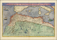
Rare Mario Cartaro View of Algiers
Rare early map of Algiers, bearing the imprint of Marius Kartarus, Fecit Roma. Kartarus was the latinized name used by master engraver Mario Cartaro.
The map drawn from the 4 sheet view of Algiers dedicated to the King of Spain by Giovanni Pacheco & Alfonso Zuniga, published in Venice in 1573, known to survive in a single example at the Civica Raccolta Bertarelli in Italy.
The view depicts the city with 48 point of importance located and named in the key at the bottom.
The city is represented in the form of a trapezoid, with the longest side parallel to the coastline. Along the other three sides, a moat full of water runs alongside the walls, with square towers at regular intervals and wedge-shaped bastions at strategic points. The map shows the Baluardo de Baluet (ie the Bastion of Bāb al-Wěd); the Bulwark Novo erected by da Yahyā Ra ‘īs: the two new bastions of the Alcazaba, and the bulwark of Bāb‘ Azūn in the corner opposite to that of Baluet and the bulwark of Cochiaperi and that of the Marina.
The turreted doors of the arsenal are also clearly visible, between these two ramparts. Within the walls there are five mosques. The qasba, Alcazaba, is represented in the upper part of the city, separated from the rest of the city by a wall.
The view provides a detailed image of the King's Palace, and of the road network, with the names of the streets that refer to the various commercial activities carried out, so we find the "road of the goldsmiths", the road of the spadari "etc.
Outside the walls, there are three fortresses, different in shape and importance.The present view show the "Castel novo finito l'anno 1569," In same year in which the Beylerbey of Algiers, Uluç Ali, set off over land toward Tunis with 5,300 Turks and 6000 Kabyle cavalry from the Kingdom of Kuku and the Kingdom of Beni Abbes to capture Tunis.
All views and maps by Mario Cartaro are extremely rare. Tooley failed to locate this view, but did a view of Rome (2 known examples) and Cyprus (4 known examples) and Raab in Hungary (3 known examples).
Algiers in the 16th Century
In 1516, the amir of Algiers, Selim b. Teumi, invited the corsair brothers Aruj and Hayreddin Barbarossa to expel the Spaniards. Aruj came to Algiers, ordered the assassination of Selim, and seized the town and ousted the Spanish in the Capture of Algiers (1516). Hayreddin, succeeding Aruj after the latter was killed in battle against the Spaniards in the Fall of Tlemcen (1517), was the founder of the pashaluk, which subsequently became the beylik, of Algeria. Barbarossa lost Algiers in 1524 but regained it with the Capture of Algiers (1529), and then formally invited the Sultan Suleiman the Magnificent to accept sovereignty over the territory and to annex Algiers to the Ottoman Empire.
Algiers from this time became the chief seat of the Barbary pirates. In October 1541 in the Algiers expedition, the King of Spain and Holy Roman Emperor Charles V sought to capture the city, but a storm destroyed a great number of his ships, and his army of some 30,000, chiefly made up of Spaniards, was defeated by the Algerians under their Pasha, Hassan.
Formally part of the Ottoman Empire but essentially free from Ottoman control, starting in the 16th century Algiers turned to piracy and ransoming. Due to its location on the periphery of both the Ottoman and European economic spheres, and depending for its existence on a Mediterranean that was increasingly controlled by European shipping, backed by European navies, piracy became the primary economic activity. Repeated attempts were made by various nations to subdue the pirates that disturbed shipping in the western Mediterranean and engaged in slave raids as far north as Iceland. By the 17th century, up to 40% of the city's 100,000 inhabitants were enslaved Europeans.
Among the notable people held for ransom was the future Spanish novelist, Miguel de Cervantes, who was held captive in Algiers for almost five years, and wrote two plays set in Algiers of the period. The primary source for knowledge of Algiers of this period, since there are no contemporary local sources, is the Topografía e historia general de Argel (1612, but written earlier), published by Diego de Haedo, but whose authorship is disputed. This work describes in detail the city, the behavior of its inhabitants, and its military defenses, with the unsuccessful hope of facilitating an attack by Spain so as to end the piracy.
A significant number of renegades lived in Algiers at the time, Christians converted voluntarily to Islam, many fleeing the law or other problems at home. Once converted to Islam, they were safe in Algiers. Many occupied positions of authority, such as Samson Rowlie, an Englishman who became Treasurer of Algiers.
The city under Ottoman control was enclosed by a wall on all sides, including along the seafront. In this wall, five gates allowed access to the city, with five roads from each gate dividing the city and meeting in front of the Ketchaoua Mosque. In 1556, a citadel was constructed at the highest point in the wall. A major road running north to south divided the city in two: The upper city (al-Gabal, or 'the mountain') which consisted of about fifty small quarters of Andalusian, Jewish, Moorish and Kabyle communities, and the lower city (al-Wata, or 'the plains') which was the administrative, military and commercial center of the city, mostly inhabited by Ottoman Turkish dignitaries and other upper-class families.
Rarity
The view is very rare. The only example we locate is in the Universitätsbibliothek Salzburg.
We note a single example which sold at Sothebys in 1986 (This example).
Engraver, draftsman, cartographer and merchant from Viterbo, although there has been serious discussion that he may have had a Nordic origin because as well as "Cartarus" and "Cartarius" he also signed "Kartarus" and "Kartarius", and he used the initials "MC" indifferently and "MK". However, his 1579 Map of Rome is signed "Marius Kartarius Viterbensis," indicating that he came from Viterbo.
Active in Rome since 1560, he became famous as an engraver of works by various artists, views of the city, and - principally - maps. In addition to the Map of Rome, one of his more noteworthy accomplishments is the rare Description of the territory of Perugia drawn by Egnazio Danti (1536-1586).
Between 1562 and 1588, Cartaro engraved geographical maps and city plans, including Cyprus and Candia of 1562, Palestine of 1563 bearing the signature of Ferrando Bertelli, Tunisi of 1574, two maps of Rome: a small one, from 1575, and a larger one from 1576 and the rare Descrittione del
Territory of Perugia in 1580.
In 1586, Cartaro moved to Naples, where he was commissioned together with Nicola Antonio Stigliola to compile an atlas of the entire Kingdom of Naples. His name appears among the engineers of the Royal Court until 1610. In Naples he lived until his death on April 16, 1620.
![[ Africa. ] Tabula IIII. Aphricae. Hae Sunt E Cognitis Totius Orbis . . . (title on verso)](https://storage.googleapis.com/raremaps/img/small/103154.jpg)
![Africae I Tab [North Africa]](https://storage.googleapis.com/raremaps/img/small/78166.jpg)