|
||

|

|
|

|
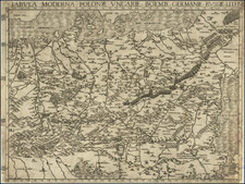
The Oldest Regional Map of Southwestern Poland
Rare early map of Southwestern Poland, drawn by Stanislaw Porebski and published in Venice.
The map is focused on the border between the historical regions of Silesia and Lesser Poland. Centered on the Duchy of Oswiecim and the Duchy of Zator, the map includes the source of the Vistula River, which crosses the map from the southwest to the northeast, extending nearly to Krakow.
The mapmaker's name, Stanislaw Porebski (1539-1581), is shown at the bottom left. Porebski studied in Padua from 1559 to 1562. Upon his return, he made an indepth study of the region which led to the publication of this map in Venice, with a dedication to Zignìmunt Myskowski, who was the chief administrator of the Oświęcim and Zator region beginning in 1563.
While Almagia opined that an earlier example (1561) might exist, no example is known and the dedication suggests that the first state is 1563.
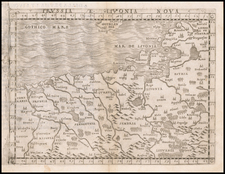
The map would later be copied by Ortelius in 1573.
States of the Map
There are 2 states:
- Dated 1563
- Dated 1565
Rarity
The map is very rare on the market.
![[ Lviv / Tarnow ] Des Koenigreichs Galizien und Lodomerien mittlere Kreise](https://storage.googleapis.com/raremaps/img/small/103315.jpg)