


|
||

|

|
|

|
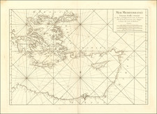
Beautiful antique Dutch sea chart of the western Mediterranean, by the Amsterdam-based mapmaker Pieter Goos.
The map covers the Mediterranean from the Straits of Gibraltar to Corfu, encompassing all of Italy, Corsica, Sardinia, the Balearic Islands, and much of the coast of North Africa, the Adriatic, and Southern Europe.
A numbered key relating the names of the smaller islands and ports is provided in the lower part of the map.
Pieter Goos (ca. 1616-1675) was a Dutch map and chart maker, whose father, Abraham Goos (approx. 1590-1643), had already published numerous globes, land and sea maps together with Jodocus Hondius and Johannes Janssonius in Antwerp. Pieter gained recognition due to the publication of sea charts. He bought the copperplates of the famous guide book for sailors, De Lichtende Columne ofte Zeespiegel (Amsterdam 1644, 1649, 1650), from Anthonie Jacobsz. Goos published his own editions of this work in various languages, while adding his own maps. In 1666, he published his De Zee-Atlas ofte Water-Wereld, which is considered one of the best sea atlases of its time. Goos' sea charts came to dominate the Dutch market until the 1670s, when the Van Keulen family came to prominence.
![[Heighten with Gold] Paskaerte Van't Westelyckste der Middelandsche Zee.](https://storage.googleapis.com/raremaps/img/small/83768.jpg)
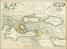
![Carte de la Turquie, de l'Arabie et de la Perse, dressée sur les mémoires les plus récents rectifiée par les observations de Messieurs de l'Académie Royale des Sciences par G. de L'Isle, géographe. [Map of Turkey, Arabia, and Persia, drawn up based on the most recent memoirs and corrected by the observations of the gentlemen of the Royal Academy of Sciences by G. de L'Isle, geographer.]](https://storage.googleapis.com/raremaps/img/small/94075.jpg)
![A Mapp of The Estates of the Turkish Empire in Asia and Europe . . . 1669 [includes Cyprus]](https://storage.googleapis.com/raremaps/img/small/85533.jpg)
![[Heightened with Gold Leaf! -- Paul's Travels ] De Reysen Christi Des Heyland en Pauli met andere syne Bloedgetuygen](https://storage.googleapis.com/raremaps/img/small/72900.jpg)