|
||

|

|
|

|
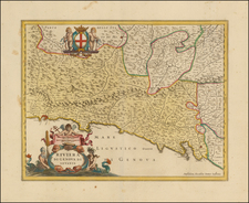
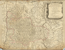
Fantastic Lafreri School map of Lombardy, representing a notable regional map published early in the history of printed cartography. This map shows the region from the thin alpine lakes in the north through the Po River. Numerous cities are shown, including Padua, Venice, Milan, Verona, Mantua, Bologna, and Bergamo, all located in this historically important part of Italy.
The map derives its contents from a 1556 map of the region published in Rome by Luchini, which itself updates an even earlier 1520 map of the region by Luca Antonio degli Uberti. This Uberti map was the first regional map of Northern Italy. This map was published in five states, of which this is the third and final Forlani state before the plate passed into the hands of the Bertelli family.
Senfelici emphasizes the importance of this map because of the rarity of all the plates in this lineage of Lombardy maps. A separate lineage of Lombardy maps was established in circa 1559 with the publication of a large Gastaldi map, of which the first state (the only state by Gastaldi) is known from a two-sheet fragment.
The map is fantastic for its early Lafreri stylistic tendencies. Towns are shown pictorially, special attention is paid to trees and forests, and, of course, mountains have their characteristic rounded shape. Pay attention to the city of Venice, which is marvelously depicted in its lagoon in the easternmost part of the map.
States
The map is known in five states.
- Date in cartouche M.D.LX.
- Date updated to MDLXI
- Date changed to 1562
- Camocio's name is erased from the plate, date updated to 1584
- Imprint changed to Apud Donatum Bertellum, MDXCII
This third state is known in only four examples, including the example presented here.
The Lafreri School is a commonly used name for a group of mapmakers, engravers, and publishers who worked in Rome and Venice from ca. 1544 to 1585. The makers, who were loosely connected via business partnerships and collaborations, created maps that were then bound into composite atlases; the maps would be chosen based on the buyer or compiler’s interests. As the maps were initially published as separate-sheets, the style and size of maps included under the umbrella of the “School” differed widely. These differences can also be seen in the surviving Lafreri atlases, which have maps bound in with varying formats including as folded maps, maps with wide, trimmed, or added margins, smaller maps, etc.
The most famous mapmakers of the School included Giacomo Gastaldi and Paolo Forlani, among others. The School’s namesake, Antonio Lafreri, was a map and printseller. His 1572 catalog of his stock, entitled Indice Delle Tavole Moderne Di Geografia Della Maggior Parte Del Mondo, has a similar title to many of the composite atlases and thus his name became associated with the entire output of the larger group.
![[ Istria, Sloveniam, Northern Croatia ] Karstia, Carniola Histria et Windorum Marchia](https://storage.googleapis.com/raremaps/img/small/95562.jpg)