


|
||

|

|
|

|
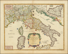
The Rare Ulrich State of the Petrus Plancius Map of Italy. Previously Thought to be a Separate Plate.
Rare late-16th- or early-17th-century state of the Petrus Plancius map of Italy which Cornelis Claesz obtained a privilege on April 17, 1592. This state, engraved by Heinrich Ulrich, updates the cartouche to reflect early Baroque sensibilities and retains the superlative decorative style and craftsmanship of Plancius, one of the most influential Dutch cartographers of the golden age of Dutch exploration.
The lower-left corner is taken up by a large scrollwork cartouche, in which the map title and a legend (Notarum explicatio) are included. Three symbols refer to the seats of patriarchs, archbishops, and bishops that are shown on the map. This is followed by an explanation of the dotted lines: "A double dotted line indicates the cart tracks, a single one the country's borders."
The map is incredibly detailed, with a large number of cities, rivers, and toponyms scattered throughout. The geography is unquestionably based on the work of Gerard Mercator, as ascribed by Schilder. Schilder states that: "The main source is Mercator's general map of Italy," however, he also states that Plancius uses other maps in Mercator's atlas series published between 1585 and 1589. The map extends further westwards to include French Provence, and this region is based on Mercator's Aquitania. The upper right incorporates Mercator's map of Hungary.
The decorative tendencies on the plate are very reflective of Plancius's work and early Dutch cartography. The map includes two sea monsters and three sailing ships, as well as a highly ornate compass rose. In all, a fantastic map.
States
Schilder suggests that the Ulrich plate (15.4.A, Vol VII) is a derivative of the Plancius plate (15.4, Vol VII). However, careful comparison of high-resolution imaging of the two maps reveals that they, in fact, come from the same plate. Some touches of re-engraving are particularly noticeable. For example, in the Balearic Sea, notice how the lowermost curls on the M and A of "Mare" have been erased. Further, notice the re-engraving of the hat on the upper left figure on the cartouche when it enters the graticulated border. All other minor details correspond exactly.
In addition, recent research has revealed that two Plancius states exist. As such, we now suggest that the map exists in three (known) states:
- By Petrus Plancius, c. 1592. Cartouche credits "Petro Plancio," and "Baptista Doetecomius Sculpsit" and shows "Cum Priviligio. . ." above. The entire cartouche is decorated with sixteenth-century Dutch sensibilities (i.e., geometric shapes with some organic features, as in many Ortelius cartouches.)
- Longitude scale now extended to top and bottom margins, meaning that the "block pattern" now extends all the way around the map. In addition, the word "annor" is updated to "annos."
- By Henrich Ulrich, circa 1600-1620. The cartouche area has been mostly re-engraved. The text remains the same, except the Doetecom attribution has been changed to Heinrich Ullrich. Further, cartouche decorations have been reengraved to reflect baroque sensibilities.
Rarity
The map is exceptionally rare. Schilder locates 6 examples of the Plancius state (London, Regensburg, Rotterdam, St. Petersburg, Vatican, and Stopp Colection), and only 3 examples of the Ulrich state (Newberry Library, Niedersachsischen Landsbibliothek,and Bayerische Staatsbibliothek).
The map is mentioned on page 251 of Catalog über die im Königlich Bayer'schen Haupt-Conservatorium der Armee befindlichen Landkarten und Pläne, Volume 1, with a date given as "1620?".
Petrus Plancius (1552-1622) was born Pieter Platevoet in Dranouter in West Flanders. He trained as a clergyman in Germany and England, but he was an expert not only in theology but in geography, cosmography, and navigation. After fleeing prosecution by the Inquisition in Brussels, Plancius settled in Amsterdam where he first began his forays into navigation and charting. As Amsterdam was a hub for trade, Plancius was able to access Portuguese charts, the most advanced in the world at that time. Plancius used these charts to become an expert in the sailing routes to India, knowledge that gained him opportunity. Plancius was one of the founders of the VOC, for whom he worked as their geographer. He also served on a Government Committee to review the equipment needed for exploratory expeditions.
![Constantinoplen en Egypten door Nicolaus Schmidt in enn zes Jarige Reystogt uyt Duytsland [shows Cyprus]](https://storage.googleapis.com/raremaps/img/small/57615.jpg)
![(Russian Language FIFA World Cup Poster) 14 й- ЧЕMПИОНАТ МИРА по ФУTБОАУ | Italia '90 [14th Soccer World Championship]](https://storage.googleapis.com/raremaps/img/small/89589.jpg)