|
||

|

|
|

|
One of Two Known Examples Private Hands.
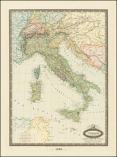
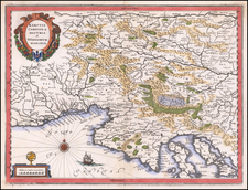
First state of this exemplary Lafreri School map of Italy and the surrounding region, published in Rome by Claudio Duchetti in 1582. This map shows the Italian peninsula with a number of cities, towns, toponyms, and other geographical features and is decorated in the attractive Italian 16th-century style.
This map is based on the 1561 Gastaldi map and incorporates elements from a 1567 Bertelli-Zenoi creation. This is the first Roman reprint of Gastaldi's defining work and this Duchetti map served as the basis for all later Roman maps of Lafreri maps of Italy.
The map is very attractive, containing a number of decorative elements including six sailing ships, a compass rose, title cartouche, and a stippled sea. Hills are shown rounded, typical of Italian cartography from the 1500s. A host of cities and towns are named. Corsica, part of Sardinia, the French Riviera, and the western Balkans are shown.
The map includes a host of interesting features. For example, at the bottom of the map, Mt. Etna is showed in vivid eruption. It is here given its traditional Italian name of Mongibello, meaning beautiful mountain. Though not mentioned in a legend, bishoprics are indicated with a spiral symbol. Venice is shown in its lagoon.
In all, a very attractive and desirable map.
Rarity
This is one of two examples of the map in private hands, as recorded by Bifolco and Ronca's extremely extensive census.
The Lafreri School is a commonly used name for a group of mapmakers, engravers, and publishers who worked in Rome and Venice from ca. 1544 to 1585. The makers, who were loosely connected via business partnerships and collaborations, created maps that were then bound into composite atlases; the maps would be chosen based on the buyer or compiler’s interests. As the maps were initially published as separate-sheets, the style and size of maps included under the umbrella of the “School” differed widely. These differences can also be seen in the surviving Lafreri atlases, which have maps bound in with varying formats including as folded maps, maps with wide, trimmed, or added margins, smaller maps, etc.
The most famous mapmakers of the School included Giacomo Gastaldi and Paolo Forlani, among others. The School’s namesake, Antonio Lafreri, was a map and printseller. His 1572 catalog of his stock, entitled Indice Delle Tavole Moderne Di Geografia Della Maggior Parte Del Mondo, has a similar title to many of the composite atlases and thus his name became associated with the entire output of the larger group.