|
||

|

|
|

|
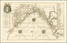
First State of Bertelli's Map of the Veneto.
Fantastic mid-16th-century map of northern Italy, showing the region between Venice and Vicenza, centered on Padua. This map is engraved in the Lafreri School style, displaying its easily identifiable ornamental tendencies.
The publication of this image completes a project started by Giacomo Gastaldi, one of the great Lafreri School artisans, but left unfinished at his death in 1566. Gastaldi was heavily involved in modernizing maps of northeastern Italy and the surrounding region, and this map of the region around Padova is both the first map to show the region with modern accuracy, as well as the first map to focus on the area around Padova (rather than on the Venetian northwest of Italy, a much larger region). Bifolco and Ronca do not specify the nature of Gastaldi's project (whether it was a manuscript or the beginning of an engraved plate), but regardless it was inherited by the Bertelli's as they acquired much of Gastaldi's work.
Detail on the map is important for its demarcations of early towns and cities. Political subdivisions of the Venetian Republic are hinted at using dotted lines, with the regions named in bold letters. Larger cities are shown in pictorial detail, foremost among these is Venice with its many buildings including St. Mark's Tower. The marshlands which define this part of the Italian coastline are demarcated using hatched lines.
The map is highly decorative in the Lafreri School style, particularly recognizable in the hills. These rounded objects are much more subtle than later Northern European pictorial hills. In addition, the stippling of the sea and a St. Mark's compass rose are further indications of this Italian design.
The map is dedicated to Giovanni Dolfin, a member of the powerful Venetian Dolfin family. Dolfin was the Bishop of Toscio in the Venetian Republica at the time of this map's publication.
Rarity & States
This map was published in four states, of which this is the first. The map was engraved by Girolamo Olgiato (Hieronymous Olgiatus) and the first two states were published by Ferrando Bertelli, with the last two states published by his successor Andrea Bertelli.
This map is very scarce on the market. The last example we trace appeared at Christie's, Paris, in 2006.
The Lafreri School is a commonly used name for a group of mapmakers, engravers, and publishers who worked in Rome and Venice from ca. 1544 to 1585. The makers, who were loosely connected via business partnerships and collaborations, created maps that were then bound into composite atlases; the maps would be chosen based on the buyer or compiler’s interests. As the maps were initially published as separate-sheets, the style and size of maps included under the umbrella of the “School” differed widely. These differences can also be seen in the surviving Lafreri atlases, which have maps bound in with varying formats including as folded maps, maps with wide, trimmed, or added margins, smaller maps, etc.
The most famous mapmakers of the School included Giacomo Gastaldi and Paolo Forlani, among others. The School’s namesake, Antonio Lafreri, was a map and printseller. His 1572 catalog of his stock, entitled Indice Delle Tavole Moderne Di Geografia Della Maggior Parte Del Mondo, has a similar title to many of the composite atlases and thus his name became associated with the entire output of the larger group.
![[Rome / Controlling The Tiber River] Parer di Gio Paolo Maggio Archit Sopra l'inondation di Roma](https://storage.googleapis.com/raremaps/img/small/85891.jpg)
![[Toscana / Tuscany] En, candidi lectores, elegantioris Italiae partis, Tusciae scilicet, topographiam. aenis nris formis excussam in hac Tabella vobis denuo damus, atque ita quidem absolute, ut nihil amplius, in ea desiderari possit, praesertim quod, cum adiacentibus Umbriae, Aemiliae, Lombardiae, & Liguriae partibus ad unguem fuerit effigiata . . .](https://storage.googleapis.com/raremaps/img/small/75549.jpg)