|
||

|

|
|

|
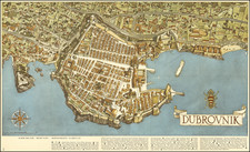
Finely engraved map of the coast of Dalmatia, extending from the Zadar area to the Sibenik area, by Paolo Forlani in Venice.
An important early map of Croatia, illustrating important early towns, rivers, fortified cities, islands, etc. Several ruins of early structures are shown, along with important bridges and towers.
In the region of the of Dinara, north of the source of the Cetina River, a fortress is shown, named Dinarić. Today, its ruins are known as Glavaš (after a nearby settlement). Further down river, there is Bergati fortress identified as Babidub and across the rivedr, the ancient ruins of Bergane. Further down river, the Fortress Nečeve (Nesuen) is shown and further down river the Bugučinc fortress (Bogosin). The island of Vissioca (Visovac) and its church are shown.
This example lacks the tablet in the title block described by Woodward, which has been described by Valeria Bella and Stefano Bifolco as likely the first state of the map, with the tablet added later.
The Lafreri School is a commonly used name for a group of mapmakers, engravers, and publishers who worked in Rome and Venice from ca. 1544 to 1585. The makers, who were loosely connected via business partnerships and collaborations, created maps that were then bound into composite atlases; the maps would be chosen based on the buyer or compiler’s interests. As the maps were initially published as separate-sheets, the style and size of maps included under the umbrella of the “School” differed widely. These differences can also be seen in the surviving Lafreri atlases, which have maps bound in with varying formats including as folded maps, maps with wide, trimmed, or added margins, smaller maps, etc.
The most famous mapmakers of the School included Giacomo Gastaldi and Paolo Forlani, among others. The School’s namesake, Antonio Lafreri, was a map and printseller. His 1572 catalog of his stock, entitled Indice Delle Tavole Moderne Di Geografia Della Maggior Parte Del Mondo, has a similar title to many of the composite atlases and thus his name became associated with the entire output of the larger group.
Paolo Forlani (fl. ca. 1560-1571) was a prolific map engraver based in Venice. All that is known of his life are his surviving maps and prints, of which there are almost 100 (185 with later states included in the total). He also produced a globe and two town books. It is likely he came from Verona and that he died in Venice in the mid-1570s, possibly of the plague.
![[ Austro-Hungary ] Germany. Austrian Dominions](https://storage.googleapis.com/raremaps/img/small/102014.jpg)