|
||

|

|
|

|
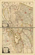
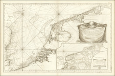
The Earliest Surviving Printing of Jacob Van Deventer's Map of Holland
Fine example of Tramezini's rare map of Holland, first published in Rome in 1556.
Tramezini's map is based upon a wall map of Holland by Jacob Van Deventer, the father of Dutch cartography.
The original map map by Van Deventer is believed to have been compiled around 1537 and printed in 1542, although there is no surviving example of the map. There was a later edition of the map in nine sheets published in Antwerp in 1558 by Bernard van den Putte, which survived in a single example (Stadtbibliothek of Breslau), but which was destroyed during the Second World War. As such, Tramezini's work, dated 1556, represents the earliest surviving example of Deventer's map.
Tramezini likely had access to maps produced in Flanders through Jacob Bos, who was the engraver of the work, and others by Tramezini.
States of the Map
- Tramezini Imprint and date of MDLVI
- Date changed to MDLVIII
Rarity
The map is rare on the market. We note two examples at auction in the past 20 years.
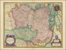
The Maps of Jacob Van Deventer
Jacob van Deventer is the father of Dutch mapmakers and a pioneer in cartographic history.
Jacob van Deventer was likely born in the Hanseatic city of Kampen around 1505 and studied in Louvain, but relatively little is known about his life. Van Deventer was the first to apply triangulation to provincial maps.
Beginning in the 1530s, Van Deventer was commissioned by the government to survey and map five northern provinces in the Low Countries. Van Deventer created five provincial maps, Brabant (1536), Holland and Utrecht (1542), Gelderland (1543), Zeeland (1547), and Friesland, Groningen, Overijssel, and Drenthe (1545). Each of the maps was prepared for printing (three in woodcut, two in copper) at a scale of 1:180,000 and probably printed in Mechelen. However, examples of the first states of these five maps survive and today they are known only through archival records and a note in Ortelius’s “Catalogus auctorum,” which mentions “Iacobus à Dauentria, Brabantiae, Hollandiae, Gelriae; Frisiae; Zelandiae Tabulas descripsit & edidit, Mechliniae.”
Later example of Van Denventer's 5 provincial maps were issued by various publishers between 1556 and 1560, but with the exception of the maps of Gelderland and Zeeland, most impressions of them were destroyed in Breslau (Wrociaw) during World War II.
As such, the earliest surviving example of these maps are Italian editions, engraved by Jacob Bos and published by Michele Tramezini between 1555 and 1558. In addition to these Italian editions, Van Deventer’s maps were copied by Sebastian Münster (1550), Abraham Ortelius (1570) and Gerard de Jode (1565 2 sheet maps of Flanders, Holland, and Brabant).
Van Deventer’s impressive multisheet maps were designed and used to decorate the walls of mansions, castles, and palaces. These maps substituted for tapestries. These sixteenth-century wall maps hung in the houses of well-to-do citizens.
Van Deventer’s province maps the foundation for future cartography with their mathematically correct representation of the complex land-water distribution in the Northern Provinces. In addition to printed maps, Van Deventer also produced many manuscript maps. However, aside from his town maps, almost nothing remains of this manuscript material. Only a single map of Het Bildt in Friesland is believed to be in his hand.
![[Low Countries] Provinces Des Pais Bas, Divisees Suivant Les Traites D'Utrecht, De Rastatt, Et D'Anvers, Faits en 1713, 1714 et 1716 Et ou les Nouvelles Barrieres sont Marquees . . . 1737](https://storage.googleapis.com/raremaps/img/small/29903.jpg)