|
||

|

|
|

|
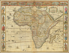
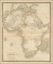
"This is the first map of the African continent, which abandons the Ptolemaic model, as well as the first map of Africa engraved on copper." - Bifolco & Ronca
A supremely important 16th-century Italian map of Africa, representing a major advancement in the cartography of the continent. The map was published in 1562 in Venice by Paolo Forlani, one of the great Italian mapmakers of the 16th century.
Forlani's map predates Giacomo Gastaldi's large eight-sheet wall map of Africa by two years, with the latter being published in Rome in 1564. Forlani dedicated the map to Tommaso Rangoni da Ravenna (1493-1577), philosopher, physician, and famous astrologer of the time, who, from 1562, was Guardian Grande of the Scuola Grande di San Marco. The dedication is followed by a brief description of Africa in 11 lines.
The toponymy is dense and updated - compared with the 1552 Ramusio-Gastaldi - especially, in the southern part of the continent. Betz provides the following discussion of the geography of the map:
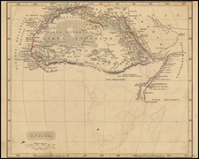
The Cuama River and the Spo Santo f (Spirito Santo River) divide from an unnamed river (the Zembere River) exiting Lago Zembere (Lake Zembere). The Zaire River flows to the west from Lake Zembere. A much smaller Nile source lake, Zaflan, is to the right of Lago Zembere. There are no Mountains of the Moon. The map shows considerable detail about the trading ports on the Eastern Africa coast. Important ports identified from south to north are: Cefala (Sofala), Mozambique Island, Quiloa, Mombaza, and Melinde (Malindi). Zenzibar Island is shown to the southeast of MELINDE R[egnum].
Forlani's Sources
The general consensus among scholars is that Forlani based his cartography largely on Gastaldi's prior output, whether in the form of his 1548 regional atlas maps, or in the mural map made for the Doge's Palace for the Council of Ten.
Bifolco & Ronca (2018: 91):
It is very likely that this map follows the handwritten mural, prepared in 1549 by Giacomo Gastaldi at the request of the Council of Ten, who in 1546 entrusted the Piedmontese cartographer with the task of creating a map of Africa and one of Asia to decorate the Ducal Palazzo. The fresco was lost, and the printed version engraved by Forlani would be the only testimony, although it does not contain any explicit reference to Gastaldi's work.
Betz draws attention to Forlani's apparent use of Gastaldi's northern and southern Africa from the 1548 atlas. As well as commenting on the likelihood that Forlani copied Gastaldi's mural map as his base:
It is interesting to note that this map appears to greatly resemble Gastaldi's eight-sheet map prepared two years later in 1564. Karrow (1993: 243) states that it is possible that Forlani had access, with or without Gastaldi's approval, to the large map of Africa that Gastaldi made for the wall of the Doge's Palace in Venice in 1549 to show the new discoveries. The author tends to agree with this theory.
The Arabian Peninsula
Detail on the Arabian Peninsula appears derived from Gastaldi's 1561 map of the Arabian peninsula, although placenames have been changed slightly. For example, Deserto de Agiaz (east of Medina) is written "Hegiaz" on the earlier map. On the presented map, a new name appears in Kuwait, "Rach," replacing "Regno de Anna." Baharem and Quessimi likely correspond to an inverted Qatar and Bahrein, which had been occupied forty years earlier by the Portuguese, before being replaced by the Ottomans in 1550. Near the present-day United Arab Emirates, Forlani reproduces Gastaldi's place names and cities.
States
First state: Date reads "M.D.LXII"
Second state: Date now reads "M.D.LX". There are no other changes.
Woodward dated the second state to circa 1566, but Bifolco and Ronca point out that the first state appears in IATO atlases that certainly date from after 1566, and therefore the map was probably amended later.
The map was extremely important and therefore among Lafreri School collections the first state is well represented. The supposed second state is known in one example at the Newberry Library. One wonders why the map known in a single example dated "1560" is assumed to be the second state, when compared to maps known in many examples dated "1562".
Paolo Forlani (fl. ca. 1560-1571) was a prolific map engraver based in Venice. All that is known of his life are his surviving maps and prints, of which there are almost 100 (185 with later states included in the total). He also produced a globe and two town books. It is likely he came from Verona and that he died in Venice in the mid-1570s, possibly of the plague.