|
||

|

|
|

|
Rare Plan of the Battle of Djerba
Anonymous engraving illustrating the Battle of Djerba, attributed to the typography of Antonio Lafreri.
The images to the events of May-June 1560, before the Christian surrender to the Turkish siege. In the cartouche it is reported that the fortress is still defended by 5,000 soldiers, that the supply supplies and ammunition are good, and that with "God's help it will be enough to defend Jerba from the insults of the Turkish army ".
Djerba
The island of Djerba had a lengthy history of visitors and invaders long before the battles of 1560. The island is mentioned in Homer’s Odyssey, as it is the supposed land of Lotus-Eaters. When Odysseus and his crew became stranded there, his men at the lotus and lost all desire to leave.
A Jewish minority has existed on the island since the sixth century BC and the island houses one of the oldest synagogues in continuous use in the world; El Ghriba has been open for over 2,000 years. The Romans also found Djerba inviting; they were responsible for the thin land bridge that connects the island to the mainland. Djerba appears in the writings of Pliny the Elder and on the Peutinger Table, which has fourth century AD origins.
In the Middle Ages, Islam came to the island, but was contested by Christians from Sicily and Aragon. These disputes produced the island’s distinctive fortified mosques. The Norman Kingdom of Sicily managed to take control of the island twice, for two decades in the twelfth century and for five decades between the thirteenth and fourteenth centuries.
In 1503, Barbary pirates took over the island, giving it over to nominal Ottoman control. Spain, worried about this large pirate base in the western Mediterranean, tried to capture the island in 1510, and again in 1520. This time they were successful, controlling the island for three years. They also had some control of the island in the 1550s.
After the 1560 Battle of Djerba, chronicled in this broadside, Europeans would no longer be able to interfere directly in Djerba affairs. The Ottoman regency of Tunis ruled over the island until 1881, after which it joined the French protectorate.
Battle of Djerba
In the winter of 1559, a multi-national Christian fleet commanded by the Genoese Giovanni Andrea Doria was assembled at Messina. The polities represented included the Maltese, the Papal States, the Genoese, the Neapolitans, and the Spanish. They set sail, with the taking of Tripoli as their goal. They stopped first in Malta, where they stayed for several months. On February 10, 1560, the fleet left for Tripoli. However, many of their crews were sick and weak, forcing their withdrawal to Djerba. They captured the island early in March of 1560.
After the victory, the Viceroy of Sicily, Juan de la Cerda, ordered a fort to be built in the European style. Construction began immediately. While the walls went up, an Ottoman fleet of nearly 100 ships under the command of the Ottoman admiral Piyale Pasha left Istanbul. They arrived at Djerba on May 11, 1560, taking the Christian forces by surprise. After a brief engagement, the Ottomans destroyed much of the Christian forces; the remaining defenders entrenched themselves in the fort. They held out for three months, but eventually had to surrender.
The defeat shocked Europe, particularly Spain, who had lost a sizeable portion of its already too small fleet. The Ottomans, emboldened, set their sights on a larger target, Malta, which they unsuccessfully laid siege to in 1565. The loss at Djerba forced Spain to change tactics and focus on the build-up of its navy, an important development on the road to the greatest European-Ottoman naval engagement, the Battle of Lepanto in 1571.
Rarity and states of the map
The fort, and this broadside, are reminders of a specific skirmish and of the larger wars between Christian Europe and the Ottoman Empire. It would make a fascinating addition to any collection of North African, sixteenth-century maritime, and Mediterranean maps.
The Lafreri School is a commonly used name for a group of mapmakers, engravers, and publishers who worked in Rome and Venice from ca. 1544 to 1585. The makers, who were loosely connected via business partnerships and collaborations, created maps that were then bound into composite atlases; the maps would be chosen based on the buyer or compiler’s interests. As the maps were initially published as separate-sheets, the style and size of maps included under the umbrella of the “School” differed widely. These differences can also be seen in the surviving Lafreri atlases, which have maps bound in with varying formats including as folded maps, maps with wide, trimmed, or added margins, smaller maps, etc.
The most famous mapmakers of the School included Giacomo Gastaldi and Paolo Forlani, among others. The School’s namesake, Antonio Lafreri, was a map and printseller. His 1572 catalog of his stock, entitled Indice Delle Tavole Moderne Di Geografia Della Maggior Parte Del Mondo, has a similar title to many of the composite atlases and thus his name became associated with the entire output of the larger group.
Antonio Lafreri (1512-1577) (also known as Antoine Lafréry and Antoine du Pérac Lafréry) was a French mapmaker, engraver, and publisher who worked in Italy. Lafreri was born in Franche-Comté and moved to Rome around 1540. Lafreri sold sheet maps but he also bound maps into books for his clients based on their interests and needs. These are the famous Lafreri atlases, important pre-cursors to the modern atlas. He also published well known works such as the Speculum Romanae Magnificentiae (ca. 1575), a collection of engraved views and images of Rome. Lafreri was well-connected to the cartographic networks of the time, collaborating with Giacomo Gastaldi, Battista Agnese, Antonio Salamanca, Donato Bertelli, Paolo Forlani, and others.
![[Christian Conquest and Fortification of Djerba in 1560] Aviso Del Successo Del Arm'ata De Christiani che si truova in Barberia, & della presa del Gerbi diretta al. S. Comendator Cambiano dal S. Paulo de la gesia Comedator; et secretario del R.S. gran Mastro de la religion de Rodi, Molto Magnifico S. Miro.](https://storage.googleapis.com/raremaps/img/small/61878.jpg)
![(Tangiers, Tzaffin, Ceuta, Arzila, and Sala) Tingis Lusitanis Tangiara. . . [on sheet with] Tzaffin [and] Salaa [and] Arzilla
[and] Septa](https://storage.googleapis.com/raremaps/img/small/54983mp2.jpg)
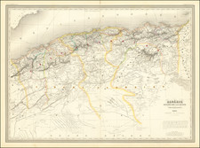
![Barbary and Bildulgerid. [on sheet with:] Egypt and Barca &c.](https://storage.googleapis.com/raremaps/img/small/70916.jpg)