|
||

|

|
|

|
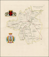
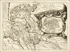
Beautifully engraved antique map of the eastern Romagna region of northern Italy, first published by Johann Baptiste Vrients in the Theatrum Orbis Terrarum in 1608.
At the top of the map is the city of Imola and the Valli di Comacchio. In the southeast is the coastal city of Rimini. The map covers San Marino as well.
In the upper-right corner is an inset map titled "Rhodiginae Peninsulae Descriptio" authored by Gaspare Bonifacio. This map shows the area around Rovigo.
This is one of the rare Johanne Baptista Vrients maps, and it only appears in the final editions of Ortelius' Theatrum Orbis Terrarum.
Van Den Broecke writes of this maps sources:
this map is based on the single sheet map of the Romagna area which Giovanni Antonio Magini (1555-1617) drew and published in 1597 (Meurer p. 189). The inset map of the area around Rovigo-Adria in Polesina, hardly a peninsula although characterised as such, derives from Giovanni, rather than Gaspar Bonifacio (1547-1635), who sent a map of this area to Pigafetta around 1602. After his death in 1604, Pigafetta's material came into the hands of Vrients (Meurer p. 117-118, 214).