|
||

|

|
|

|
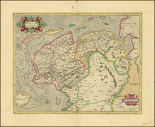
Rare second state of Camocio's fine map of Roman Province of Gallo-Belgica.
The Camocio map of Flanders represents the first Venetian derivate of the work of Gilles Boileau de Bouillon. Published in 1557, Buillon's map (known in a single example), was the basis for all maps of the region for the next several decades. Bouillon's name appears in Ortelius' Catalogus auctorum as a source for his map of Flanders. Originally oriented with south at the top, Boileau's map was published in Antwerp by Johannes Liefrinck apparently intended to illustrate an edition of the De Bello Gallico (although it survives in only single copy); showing several toponyms in Latin and some Roman roads that connect the various cities.
The map shows Belgium with Northern France, Belgium and Dutch Brabant with a part of the German Rhineland between Paris, Boulogne-sur-Mer, Metz and Cologne.
Bifolco notes that the Camocio's map is also based on the Pirro Ligorio map, published in Rome in 1558, as both are oriented with north at the top, and Camocio repeates the errors of Ligorio and other minor details that are not found in the Bouillon original. Similarly, the ommissions of Ligorio are repeated by Camocio. Almagià believed all of the Italian editions of the original Bouillon were based upon a lost Flemish copy of the map, although Bifolco found Almagia's theory to be unconvincing.
The map is known in 5 states:
- First State: Dated Anno. M. D. LXI. (no maker)
- Second State: Dated Anno. M. D. LXIII. (no maker)
- Third State: Imprint Apud Joannem Franciscum Camocium.
- Fourth State: Dated M.DLXXXV. Camocio name removed.
- Fifth State: Dated MDCXXXVIIII. With imprint Apud Donatum Bertellum.
Rarity
All states of the map are extremely rare.
The Lafreri School is a commonly used name for a group of mapmakers, engravers, and publishers who worked in Rome and Venice from ca. 1544 to 1585. The makers, who were loosely connected via business partnerships and collaborations, created maps that were then bound into composite atlases; the maps would be chosen based on the buyer or compiler’s interests. As the maps were initially published as separate-sheets, the style and size of maps included under the umbrella of the “School” differed widely. These differences can also be seen in the surviving Lafreri atlases, which have maps bound in with varying formats including as folded maps, maps with wide, trimmed, or added margins, smaller maps, etc.
The most famous mapmakers of the School included Giacomo Gastaldi and Paolo Forlani, among others. The School’s namesake, Antonio Lafreri, was a map and printseller. His 1572 catalog of his stock, entitled Indice Delle Tavole Moderne Di Geografia Della Maggior Parte Del Mondo, has a similar title to many of the composite atlases and thus his name became associated with the entire output of the larger group.
![[ Lower Rhine River & Wesser River Region ] Die dritte Tafel des Rheinstroms / Innhaltend das Nider Teutschlandt](https://storage.googleapis.com/raremaps/img/small/81288.jpg)